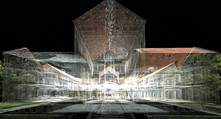
A historic landmark in Serbia has been digitally reconstructed using a high precision reality capture workflow built around terrestrial laser scanning and structured data processing. The result is a fully navigable 3D model that preserves architectural detail at a level suitable for engineering, conservation, and visualization use cases.
Leica RTC360 delivers high speed LiDAR scanning with automated registration support
At the core of the project is the Leica RTC360, a high performance terrestrial laser scanner designed for rapid site capture. The system operates with a scan rate of up to 2 million points per second, allowing dense point clouds to be generated in minutes rather than hours.
Key technical characteristics of this platform include:
- Range up to approximately 130 meters, suitable for both indoor and large exterior structures.
- Integrated HDR imaging system that captures full dome imagery aligned with the point cloud.
- VIS technology (Visual Inertial System), which enables automated pre-registration of scans in the field.
- Sub-centimeter accuracy under controlled conditions, making it suitable for engineering-grade documentation.
In practical terms, the RTC360 is optimized for projects where speed and positional consistency across multiple scans are critical, especially when capturing complex geometry such as historical facades.
Leica BLK360 G2 enables compact scanning for tight spaces and rapid deployment
Complementing the main scanner, the Leica BLK360 G2 provides a more compact and flexible capture option. This second generation unit is designed for portability while maintaining a high level of detail.
Relevant technical details include:
- Scan rate up to 680,000 points per second.
- Range up to 45 meters, targeting interiors and confined environments.
- Lightweight design around 1 kg, enabling quick repositioning across multiple scan stations.
- Integrated imaging for colorized point clouds.
The BLK360 G2 typically fills coverage gaps in areas where larger scanners are less practical, ensuring continuity in the final dataset.
Leica Cyclone REGISTER 360 PLUS processes point cloud data into unified 3D environments
All captured data was processed using Leica Cyclone REGISTER 360 PLUS, a platform specifically developed for managing and registering large point cloud datasets.
Core capabilities of this software include:
- Automated and manual registration workflows combining VIS data and cloud-to-cloud alignment.
- Handling of large datasets with efficient visualization and QA tools.
- Export pipelines to CAD, BIM, and digital twin platforms.
- Integration with Leica’s broader ecosystem for end-to-end reality capture.
This stage is where raw scans are transformed into a coherent spatial model, enabling accurate measurements, virtual navigation, and further modeling workflows.
High density point cloud reconstruction supports digital preservation and engineering use cases
The combined workflow demonstrates how modern LiDAR systems are increasingly used beyond surveying into cultural heritage preservation.
High resolution point clouds allow:
- Long term archival of structures with measurable geometry.
- Remote inspection and planning without repeated site visits.
- Integration into digital twin environments for asset management.
- Visualization for public engagement and education.
In this case, the Serbian landmark is not only documented but effectively recreated in a digital format that can be reused across disciplines.
About Leica Geosystems
Leica Geosystems is part of Hexagon AB and operates as one of the global leaders in measurement and geospatial solutions. The company focuses on laser scanning, GNSS, total stations, and reality capture technologies.
Key figures:
- Founded in 1819, with over 200 years of history in precision measurement.
- Operates in more than 100 countries worldwide.
- Parent company Hexagon employs over 24,000 people globally.
- Strong presence in construction, surveying, infrastructure, and public safety sectors.
Leica’s reality capture portfolio, including RTC and BLK series scanners, continues to define the transition toward data driven digital environments across engineering and heritage applications.


