Surveyors have successfully mapped the historic underground tunnel system beneath the English city of Exeter using a fully integrated geospatial workflow built around Trimble positioning and scanning technology.
The project combined GNSS control, robotic total station measurements, and high accuracy terrestrial laser scanning to capture the geometry of one of the United Kingdom’s most unusual medieval infrastructure systems.
The survey was carried out by the team at Benchmark Surveys, who used a combination of Trimble instruments to overcome the difficult environmental conditions inside the narrow, dark tunnel network that dates back to the 14th century.
Trimble R12i GNSS and S9 Total Station Provided High Precision Control Network
The workflow began with establishing accurate survey control around the site using the Trimble R12i GNSS receiver, one of the company’s flagship survey grade positioning systems.
The R12i is known for its integrated inertial measurement unit (IMU) technology, which allows surveyors to capture tilted measurements without leveling the pole. This capability significantly speeds up control point collection in constrained environments where traditional vertical pole positioning is difficult.
To extend this control network into areas where satellite signals cannot reach, the team used the Trimble S9 robotic total station.
The S9 is designed for high precision engineering and monitoring applications and can achieve millimeter level accuracy when establishing local control networks. By combining GNSS derived coordinates with total station observations, the surveyors created a stable positional framework connecting surface reference points with the underground tunnel system.
This hybrid control approach is standard practice in complex infrastructure surveys where satellite visibility is limited or nonexistent.
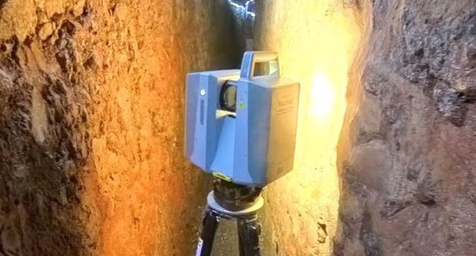
Trimble X7 and X12 Laser Scanners Captured 131 Underground Scans With Minimal Drift
With the control network established, the team deployed Trimble X7 and Trimble X12 terrestrial laser scanners to capture the interior geometry of the tunnels.
A total of 131 underground scans were collected along with 243 above ground reference points to maintain accurate alignment throughout the survey.
The X7 scanner is widely used for construction and building documentation thanks to its automated calibration and self leveling capabilities. The X12, designed for high precision industrial scanning, offers extremely dense point clouds and high positional accuracy even in complex environments.
One particularly useful feature for this project was the integrated LED illumination system, which allowed the scanners to operate effectively inside the dark, confined spaces of the medieval tunnels without requiring extensive additional lighting.
The scanning workflow produced a detailed three dimensional model of the underground network while maintaining tight alignment between scans. According to the survey team, drift across the network remained minimal thanks to the integrated control system and careful scan registration process.
Why Mapping Historic Underground Infrastructure Requires Hybrid Survey Technology
Surveying historic underground structures presents a unique set of technical challenges. Satellite positioning is unavailable, tunnel geometry is often irregular, and lighting conditions are typically poor.
Traditional survey methods alone would struggle to capture the full complexity of these environments efficiently.
By combining GNSS positioning, total station control, and terrestrial laser scanning, the survey team was able to leverage the strengths of each technology. GNSS provides global coordinate accuracy, total stations extend precision into satellite denied areas, and laser scanners rapidly capture dense three dimensional geometry.
In this case, the integrated workflow allowed surveyors to document the Exeter tunnel system with modern digital precision while minimizing time spent working inside the confined historic structure.
Why Projects Like the Exeter Tunnel Survey Matter for Digital Heritage Preservation
From a broader geospatial perspective, projects like this demonstrate how modern survey technology is transforming the documentation of historic infrastructure.
Medieval tunnel systems were originally built to transport fresh water through the city and remain one of Exeter’s most distinctive historical features. Creating accurate digital models of these structures allows engineers, archaeologists, and city planners to monitor structural stability, manage tourism infrastructure, and preserve cultural heritage.
The ability to generate detailed digital twins of underground heritage sites is becoming increasingly important as cities seek to balance preservation with modern urban development.
In my view, what makes this project particularly interesting is not just the technology itself but the workflow integration. When GNSS, total stations, and laser scanning operate within a unified ecosystem, surveyors can transition seamlessly between surface and underground environments without sacrificing positional accuracy.
That level of interoperability is becoming a defining trend in modern geospatial field operations.
About Trimble
Trimble Inc., headquartered in Sunnyvale, California, is one of the world’s leading providers of positioning technology and geospatial solutions. The company develops hardware, software, and services used across surveying, construction, agriculture, transportation, and infrastructure industries.
Trimble employs over 12,000 people worldwide and generates more than $3.7 billion in annual revenue. Its positioning technologies are used in more than 150 countries, supporting applications ranging from precision agriculture and construction automation to high accuracy surveying and mapping.
Within the geospatial sector, Trimble’s portfolio includes GNSS receivers, robotic total stations, terrestrial laser scanners, mobile mapping systems, and integrated software platforms designed to streamline data capture and spatial analysis workflows.


