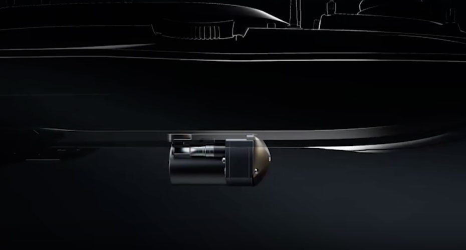
CHCNAV has announced the new HN-400M, a compact dual frequency multibeam echosounder designed to streamline hydrographic surveying while delivering high precision bathymetric data in both inland and offshore environments.
As hydrographic projects increasingly rely on unmanned surface vessels and rapid deployment workflows, the HN-400M enters the market as an integrated solution that combines multibeam sonar, GNSS positioning, and a high precision inertial measurement unit in a lightweight package weighing just 3.5 kg.
Dual Frequency Sonar Performance
The HN-400M supports both 400 kHz and 550 kHz operation, giving survey teams the flexibility to adapt to varying water conditions and project requirements.
The 550 kHz mode is optimized for shallow water applications where maximum detail and bottom definition are critical. Meanwhile, the 400 kHz mode uses FM CHIRP technology to improve performance in deeper or more turbid waters where signal penetration becomes increasingly important.
This flexibility allows a single platform to handle a broad range of surveying tasks without requiring separate sonar systems.
High Precision Motion Compensation
One of the standout specifications is the integrated IMU, which delivers roll and pitch accuracy of 0.03 degrees.
Motion compensation is one of the most important factors affecting bathymetric survey quality. Even minor vessel movement can introduce errors into seabed models and depth measurements. By integrating a survey grade IMU directly into the echosounder, CHCNAV simplifies installation while helping maintain data consistency in dynamic operating conditions.
The system also includes integrated GNSS positioning and a sound velocity sensor, reducing the need for additional external hardware.
145° Swath Coverage
The HN-400M offers a 145 degree swath angle and can map areas up to six times the water depth in a single pass.
For hydrographic contractors and government agencies, wider coverage directly translates into greater efficiency. Fewer survey lines mean shorter project timelines, lower vessel operating costs, and faster delivery of bathymetric datasets.
This capability makes the system particularly attractive for dredging verification, navigation channel maintenance, reservoir mapping, and port infrastructure inspections.
Designed for USV Deployment
Compactness is clearly a major focus of the HN-400M design.
At just 3.5 kg and measuring 161.5 × 111.5 × 179 mm, the system is well suited for installation on unmanned surface vessels where payload capacity is often limited. CHCNAV also states that the unit requires no calibration during installation, allowing operators to deploy more quickly and spend less time on system setup.
As autonomous survey platforms become more common across the hydrographic industry, lightweight integrated payloads like the HN-400M are becoming increasingly valuable.
Technical Specifications
| Specification | CHCNAV HN-400M |
|---|---|
| System Type | Dual Frequency Multibeam Echosounder |
| Operating Frequencies | 400 kHz / 550 kHz |
| Sonar Technology | FM CHIRP |
| Survey Range | 0.2 to 200 m |
| Depth Resolution | <10 mm |
| Swath Coverage | 145° |
| Coverage Width | Up to 6× Water Depth |
| IMU Accuracy | 0.03° Roll and Pitch |
| GNSS Positioning | Integrated |
| Sound Velocity Sensor | Integrated |
| Weight | 3.5 kg |
| Dimensions | 161.5 × 111.5 × 179 mm |
Hydrographic Survey Applications
The HN-400M is designed for a wide range of marine and inland water projects, including:
- Channel dredging surveys.
- River and lake mapping.
- Port inspections.
- Bridge foundation assessments.
- Reservoir surveys.
- Offshore hydrographic operations.
- Underwater infrastructure inspections.
- Unmanned surface vessel missions.
- Expert Analysis.
The most noteworthy aspect of the HN-400M is not any single specification but the overall level of integration. Traditional multibeam survey systems often require separate sonar heads, motion sensors, positioning equipment, and lengthy calibration procedures before work can begin.
CHCNAV is clearly targeting a new generation of hydrographic workflows where survey teams need faster mobilization, reduced system complexity, and seamless deployment on autonomous platforms. The combination of dual frequency sonar, integrated navigation sensors, wide swath coverage, and lightweight construction makes the HN-400M particularly well positioned for organizations looking to increase productivity without compromising data quality.
As hydrographic surveying continues moving toward autonomous operations and rapid response deployments, products like the HN-400M represent the direction many professionals are likely to follow.
About CHCNAV
CHCNAV is a global manufacturer of geospatial and positioning technologies serving the surveying, construction, agriculture, marine, and autonomous systems sectors. The company operates in more than 140 countries and is part of Huace Group, one of the world’s largest geospatial technology organizations. CHCNAV’s portfolio includes GNSS receivers, machine control systems, LiDAR platforms, mobile mapping solutions, hydrographic survey equipment, and autonomous navigation technologies used by professionals worldwide.


