Mining technology continues to move beyond simple mapping and visualization, and Trimble’s latest Rock Mass AI capability is a strong example of that shift. Integrated into Trimble Mine Insights, the new tool automatically extracts geological discontinuities from drone and laser scan generated 3D models, helping mining teams characterize rock masses faster, more consistently, and with significantly less field exposure.
The technology is designed to identify critical structural features including joints, fractures, faults, dip angles, and strike orientations directly from high resolution digital mine faces. Instead of manually collecting and processing geological measurements, engineers and geologists can now generate rock mass assessments from remotely captured data.
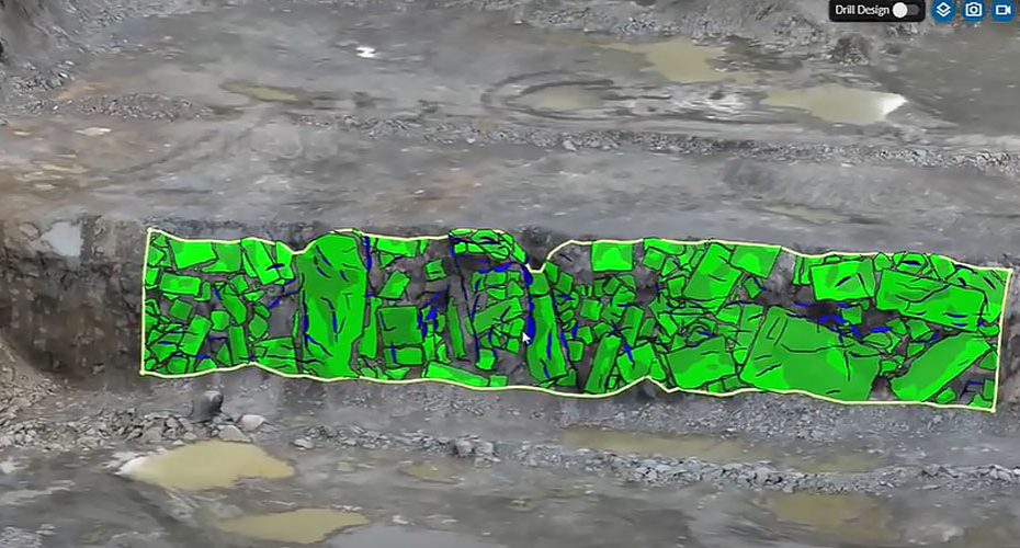
AI Rock Mass Mapping
Traditional face mapping remains one of the most time consuming and potentially hazardous tasks in open pit mining operations. Geologists often need to work close to active pit walls to collect discontinuity measurements, exposing personnel to rockfall hazards and other operational risks.
Trimble’s Rock Mass AI automates much of this process by analyzing 3D models created from drone photogrammetry or terrestrial scanning workflows. The software detects geological structures and classifies discontinuities across the entire exposed face, producing a far more comprehensive dataset than can typically be gathered through manual field observations alone.
The result is faster geological interpretation while reducing exposure to high risk working environments.
Automated RMR and RQD Calculations
One of the most valuable aspects of the system is its ability to automate calculations that are often performed manually.
Rock Mass Rating (RMR) and Rock Quality Designation (RQD) are widely used geotechnical indicators that help mining companies assess rock stability, excavation conditions, and blast design requirements.
By automatically extracting structural measurements and generating these parameters, the software reduces administrative workload while improving consistency between assessments. Geotechnical specialists can spend less time entering data into spreadsheets and more time evaluating the engineering implications of the results.
For large mining operations where hundreds of benches may require evaluation throughout the year, the productivity gains could be substantial.
Better Drill and Blast Optimization
Accurate knowledge of rock structure plays a major role in drilling and blasting performance.
Fracture orientation, joint spacing, and discontinuity density all influence fragmentation results, wall stability, and explosive energy distribution. Traditional sampling methods often capture only a limited portion of these characteristics.
Because Rock Mass AI evaluates the entire mapped surface, mine planners gain access to a much richer understanding of actual rock mass behavior. This information can be incorporated into drill and blast design workflows, potentially improving fragmentation consistency while reducing overbreak and dilution.
The technology also creates opportunities for more data driven blast optimization strategies across large mining sites.
Digital Geology at Scale
The broader significance of this announcement extends beyond simple automation.
Mining companies have spent years investing in drones, laser scanners, digital twins, and cloud based operational platforms. However, collecting data is only the first step. The real challenge is transforming massive datasets into actionable engineering intelligence.
Rock Mass AI represents an important move toward automated geotechnical interpretation, where software performs much of the repetitive analysis and specialists focus on decision making.
As AI adoption expands across mining operations, tools like this are likely to become standard components of modern mine planning and ground control programs.
Industry Perspective
What makes this development particularly interesting is that it addresses two persistent challenges simultaneously: workforce safety and geotechnical productivity.
Many mining companies already capture drone data on a daily or weekly basis, but extracting meaningful geological information from that data often remains a bottleneck. By embedding AI directly into the interpretation workflow, Trimble is moving beyond visualization and into engineering automation.
The long term value may be less about replacing geologists and more about allowing small technical teams to analyze far larger volumes of geological data than previously possible. In an industry increasingly focused on productivity, risk reduction, and operational efficiency, that combination is likely to attract significant attention.
About Trimble
Trimble is a global technology company serving the construction, agriculture, transportation, geospatial, and mining sectors. Founded in 1978, the company operates in more than 150 countries and employs approximately 12,000 people worldwide. Trimble reported annual revenue of roughly $3.7 billion in recent fiscal reporting and continues to invest heavily in positioning technologies, reality capture, automation, and AI driven operational solutions across industrial markets.


