EarthDefine has launched its Buildings Footprints 3D API, opening programmatic access to detailed building level geospatial data across the United States and giving developers a way to retrieve individual structure records without licensing and processing an entire nationwide dataset.
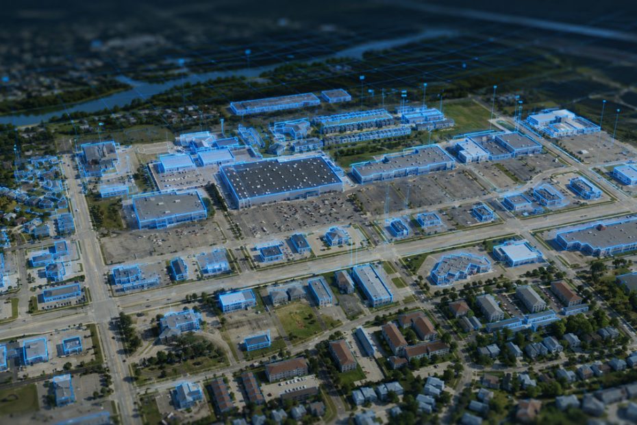
The new REST API provides access to more than 200 million building footprints and over 274 million address points linked directly to structures. Available attributes include building height, ground elevation, estimated story count, gross area, roof slope and total building volume.
The launch is particularly relevant for applications where the building itself, rather than a parcel, address or generalized map feature, needs to become the basic unit of analysis.
Building Data On Demand
EarthDefine already offers its Building Footprints 3D dataset for large scale licensing. The API changes the delivery model by allowing software to request only the structures needed at a particular moment.
Queries can be made using an address, geographic coordinates or a bounding area. Results are returned as JSON through a REST based interface designed for direct integration into GIS software, property platforms, insurance models and other enterprise applications.
EarthDefine says average API response times are below 100 milliseconds, making the service suitable for applications where building information needs to be retrieved interactively rather than processed through offline geospatial workflows.
The underlying dataset is refreshed quarterly, according to the company, while EarthDefine performs a complete national update cycle every two years.
That distinction is important. The company is not creating a simplified API specific dataset. It is exposing the same building information used in its bulk licensing business through a different delivery mechanism.
More Than Building Footprints
A simple building polygon is already useful for mapping, but the additional 3D and derived attributes substantially expand the potential applications of the API.
Building heights and ground elevations can support urban modeling, telecommunications planning, line of sight analysis and exposure assessments. Estimated story counts, gross areas and building volumes can add another layer of information for property intelligence and insurance applications.
Directly connecting more than 274 million address points to individual structures is also significant because conventional geocoding frequently identifies an address location without necessarily establishing a precise relationship with the physical building occupying the site.
For logistics, property assessment and risk modeling, that structure level connection can be more valuable than simply placing a coordinate somewhere within a parcel.
EarthDefine’s underlying Building Footprints 3D product is AI derived and provides nationwide building footprint information with height and base elevation data. The company’s broader geospatial portfolio also includes tree mapping, canopy height, land cover, elevation models, impervious surfaces, parking lots and its newer Clutter3D product.
API Pricing Starts at $750
EarthDefine is offering API packages beginning at $750 for 5,000 calls. Purchased calls remain valid for one year or until the allocation is consumed, while higher volume deployments are available with volume pricing.
At the entry price, that works out to $0.15 per API call before any volume discount.
That pricing makes the API notably different from a conventional open mapping dataset. EarthDefine is positioning it as commercial geospatial infrastructure for organizations where authoritative and frequently refreshed structure information has enough operational value to justify per request data costs.
Bulk licensing remains available for organizations performing analysis over very large geographic areas or the entire national dataset.
Why the API Matters
The most interesting part of this launch is not the existence of another building footprint database. It is the shift from geospatial datasets being treated primarily as files to geospatial intelligence being consumed as an application service.
For many software developers, downloading a nationwide building database is inefficient. It creates storage requirements, update procedures, spatial database infrastructure and synchronization issues even when an application might need information for only a handful of structures at a time.
An API removes much of that burden.
This could make detailed building intelligence considerably easier to incorporate into insurance quoting systems, real estate platforms, routing applications, utility planning tools, solar assessment systems and location intelligence products.
There is also a broader trend behind the announcement. High resolution geospatial information is increasingly moving closer to conventional software development. Developers no longer necessarily need a dedicated GIS processing pipeline to use sophisticated spatial datasets if the relevant information can be requested through familiar REST endpoints and returned as structured JSON.
EarthDefine appears to understand that transition well.
The real competitive question will therefore be less about whether the company can map buildings and more about how reliably it can keep those building attributes current, consistent and accessible as customers begin embedding them into production systems.
More Geospatial APIs Planned
The Buildings Footprints 3D API is intended to be the beginning of a broader API strategy.
EarthDefine says additional endpoints and building level attributes are planned during 2026, and CEO Vikalpa Jetly described building information as a natural starting point because of the number of downstream applications that depend on it.
If the company extends the same delivery model to other products in its catalog, developers could eventually combine buildings, vegetation, terrain and land surface information through a common on demand geospatial infrastructure.
About EarthDefine
EarthDefine is a Redmond, Washington based geospatial data company specializing in AI generated, high resolution mapping products for the United States. Its portfolio covers built environments, vegetation and land surfaces, including Building Footprints 3D, Tree Map, Tree Locations, Canopy Height Model, DEM and DSM elevation products, Impervious Map, Land Cover, Parking Lots and Clutter3D.
The scale of its datasets illustrates the amount of imagery processing behind the platform. The new Buildings Footprints 3D API exposes more than 200 million structures and over 274 million structure linked address points. Earlier EarthDefine work on its national Tree Map involved processing approximately 120 TB of aerial imagery and mapping more than 550 million acres of tree cover.
EarthDefine is headquartered at 8410 154th Avenue NE in Redmond, Washington, and continues to market its nationwide datasets both through direct licensing and increasingly through API based access.
Source: www.earthdefine.com