Aggregated GPS data collected from thousands of Dutch vehicles during the annual summer holiday period provides a detailed picture of how seasonal travel redistributes traffic flows across Europe. The dataset highlights predictable peak travel windows, dominant international routes, and the growing strategic value of vehicle GPS telemetry for transport analytics.
GPS Data Confirms Late July and Early August as Peak Mobility Window
The Dutch summer holiday period, commonly linked to the bouwvak construction shutdown and staggered regional school vacations, generates one of the most concentrated outbound travel waves in Western Europe. Despite efforts to spread departures across regions of the Netherlands, GPS traces show a clear clustering of long distance trips in late July and early August.
Vehicle movement data indicates that private cars, caravans, and camper vans account for a significant share of cross border traffic during this period, reinforcing the importance of road based travel in Dutch holiday mobility patterns.
France and Germany Dominate Dutch Cross Border Travel Routes
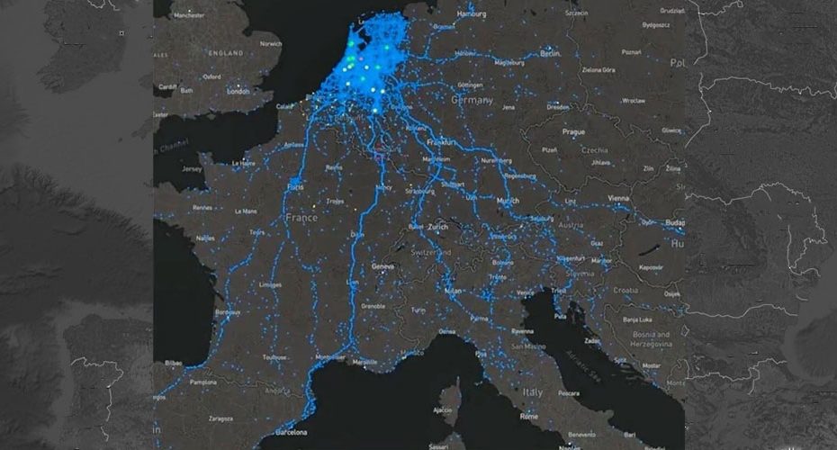
Spatial analysis of GPS tracks highlights two primary destination corridors. Southern routes toward France show the highest traffic density, particularly toward coastal regions and camping destinations. Routes into and through Germany form a secondary but highly consistent flow, serving both as destinations and transit corridors toward Central and Southern Europe.
These corridors temporarily function as seasonal transport backbones, carrying traffic volumes far above annual averages within narrow time windows.
Transport GPS Data Exposes Recurrent Congestion and Infrastructure Stress Points
The concentration of GPS tracks reveals persistent bottlenecks that repeat annually. Border crossings, major highway junctions, alpine transit routes, and access roads to coastal regions consistently emerge as high stress zones.
From a transport technology perspective, this reinforces the value of historical GPS datasets for predictive congestion modeling. Traffic authorities and navigation platforms can use such data to forecast pressure points, optimize traffic signaling, and prepare emergency and roadside services for peak demand.
Mobility Analytics Moves Beyond Navigation Into Strategic Planning
The Dutch summer travel dataset illustrates how anonymized consumer vehicle GPS data now delivers insights traditionally derived from fixed sensors or manual traffic counts. Modern vehicle telemetry enables near real time visibility into travel behavior, route choice, and temporal clustering at a continental scale.
For navigation providers, logistics platforms, and public agencies, these seasonal travel patterns offer critical input for AI driven routing algorithms, travel time reliability models, and infrastructure investment planning.
Seasonal Travel Acts as a Natural Stress Test for GPS Based Systems
Large scale holiday migration events such as the Dutch summer break function as real world stress tests for Europe’s transport networks. GPS based mobility intelligence allows these events to be measured, analyzed, and modeled with increasing precision.
As connected vehicles become more widespread and data resolution improves, GPS telemetry will play a growing role in managing peak travel demand, cross border coordination, and long term transport resilience.


