Welsh renewable energy developer Wind2 is expanding its use of Lidar for wind resource assessment, working with ZX Measurement Services to deploy and operate ZX Lidars technology across selected projects in its development portfolio.
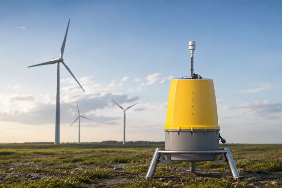
The program combines the ZX 300e vertical-profiling wind Lidar with deployment services, field support, communications and autonomous power solutions. Rather than treating remote sensing as a supplementary measurement tool, Wind2 is increasingly using Lidar as the primary source of site-specific wind data during the early stages of project development.
Wind2 had previously operated a fleet of SoDAR systems before purchasing a ZX 300 in June 2025. That unit was subsequently upgraded to the newer ZX 300e specification through ZX Lidars’ Turn Me On program.
ZX 300e Measures Wind to 300 Meters
On one current Wind2 campaign, the ZX 300e is collecting wind measurements at heights reaching 250 meters, allowing the developer to characterize conditions across the rotor swept area of the latest generation of large wind turbines.
The instrument itself has a specified Lidar measurement range of 10 to 300 meters and can collect data at 10 user-configurable measurement heights. ZX Lidars specifies wind-speed accuracy of 0.1 m/s against a calibrated moving target and wind-direction variation below 0.5 degrees.
The system uses continuous-wave Doppler Lidar technology. Laser light is focused at selected heights and backscattered by aerosols such as dust, moisture and other particles moving with the air mass. Changes in the frequency of the returned light are then used to calculate wind velocity.
ZX 300e operates at a sampling rate of 50 Hz and supports true one-second and 10-minute averaging. According to ZX Lidars, the system can maintain more than 94% data availability even in clear-air conditions at 300 meters.
Wind Shear and Turbulence Data
Height is only part of the value of the measurement campaign.
ZX 300e can also provide vertical wind shear information and turbulence intensity measurements, giving developers additional information about how atmospheric conditions vary through the height of the rotor.
The latest platform includes what ZX Lidars describes as cup-equivalent machine-learning turbulence intensity measurement, known as METICE. The model is also backed by an IEC classification covering measurement heights from 21 to 200 meters.
This becomes increasingly relevant as rotor diameters and turbine tip heights grow. A conventional meteorological mast may provide excellent reference measurements, but extending a mast to the heights required to characterize an entire modern rotor can significantly increase engineering complexity, permitting requirements and installation costs.
A ground-based Lidar can instead measure multiple heights from a comparatively small installation on the site.
Lidar-First Wind Assessment
Wind2’s decision to adopt a Lidar-first strategy on selected developments reflects a wider technical change in wind resource assessment.
The important point is not simply that Lidar can replace some mast measurements. Its greater strategic value is the ability to begin collecting high-altitude wind data relatively early and to reposition measurement equipment as project layouts evolve.
That flexibility can become particularly useful during the development phase, when turbine locations, hub heights and potential turbine models may still be changing.
From a technical perspective, the Wind2 campaign illustrates why remote sensing is becoming more closely integrated into the core development process rather than being treated as a specialist measurement option. When turbines operate across increasingly large vertical sections of the atmosphere, measuring conditions close to hub height alone provides only part of the aerodynamic picture.
Collecting wind speed, shear and turbulence information through the rotor envelope gives developers a stronger dataset for energy-yield calculations, turbine selection and site characterization.
Low-Power Remote Operation
Power consumption is another significant specification for long-duration remote campaigns.
ZX 300e requires 44 W and operates from a 12 V supply. ZX Lidars specifies an operating temperature range from -40°F to 122°F, equivalent to -40°C to 50°C. The instrument weighs 55 kg, carries an IP67 environmental rating and has a five-year warranty with a stated 60-month service interval.
Low continuous power demand matters because wind measurement locations are frequently remote from utility infrastructure. Reducing the energy requirements of the Lidar can extend autonomous operation while reducing the size and operating demands of off-grid power systems.
ZX Measurement Services provides that surrounding infrastructure as part of its turnkey offering, including installation, power supply, communications and ongoing field support.
The service business was established in 2018. By its fifth anniversary in 2023, ZX Measurement Services reported more than 100 Lidar deployments across 12 countries and management of more than 550,000 hours of customer wind data.
Wind2 Renewable Energy Portfolio
Wind2 was founded in 2016 and operates as an independent UK renewable energy developer. The company says its team has grown to more than 30 people and it works with partners including Octopus Energy Generation and EDP Renewables.
Its current portfolio includes projects ranging from smaller onshore wind developments to larger hybrid energy parks. Among them is the proposed Lairdmannoch Energy Park in Scotland, designed for up to 100 MW across 60 MW of wind generation, 20 MW of solar and 20 MW of battery storage. Windburn Wind Farm is being developed with up to 14 turbines and approximately 72 MW of installed capacity.
The increasing use of high-altitude remote wind measurement fits naturally with such projects, particularly where turbine configurations are still being optimized during development.
About ZX Lidars
ZX Lidars traces its commercial wind Lidar business to ZephIR Ltd., founded in 2007 following years of research into laser-based atmospheric measurement. The company is owned by UK-based Fred. Olsen Ltd.
Its systems are used for onshore, offshore and turbine-mounted wind measurement. ZX Lidars reported more than 18,000 deployments across over 100 countries as of 2024, while earlier analysis of 500 ZX 300 deployments demonstrated the scale of its accumulated validation dataset.
The company also states that its product family supported more than £150 billion in wind farm financing during a five-year period, reflecting the growing role of bankable Lidar datasets in commercial wind energy development.