Detroit has taken a practical step toward data driven urban management by deploying a vehicle mounted mobile mapping system from Trimble to capture citywide street level data. The initiative, known as Detroit Street View, combines panoramic imagery with LiDAR scanning to create a detailed digital representation of the city’s physical environment.
Mobile mapping with LiDAR enables full city scale reality capture in Detroit
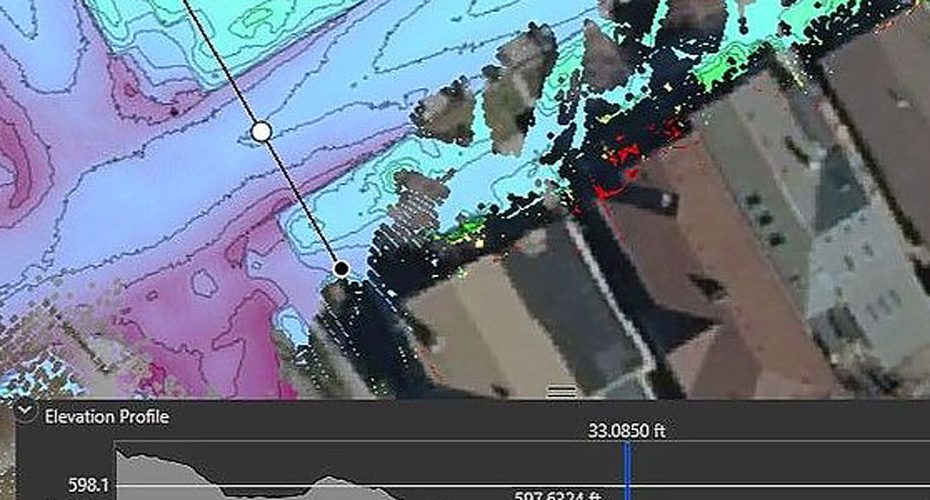
Instead of relying on fragmented surveys or outdated GIS layers, Detroit’s GIS team used a mobile mapping platform mounted on vehicles to continuously collect spatial data across urban streets. This approach allows for rapid acquisition of high density point clouds and synchronized imagery, significantly reducing the time and cost required to build a comprehensive geospatial dataset.
From a technical standpoint, this type of system integrates GNSS positioning, inertial measurement units, cameras, and LiDAR sensors into a single workflow. The result is a georeferenced dataset that can be directly used for mapping, asset inventory, and infrastructure analysis without extensive post processing delays.
Detroit uses geospatial data to challenge census estimates and improve planning accuracy
One of the most notable outcomes of the project was its use in validating population data. By analyzing real world building occupancy and urban density patterns, Detroit was able to challenge inaccuracies in U.S. Census estimates, highlighting how high resolution geospatial data can influence policy and funding decisions.
Beyond that, the dataset is already supporting cross departmental operations. City planners, infrastructure teams, and public works departments can access up to date visual and spatial data to make faster and more informed decisions. This reduces reliance on manual inspections and improves coordination between agencies.
From static GIS layers to dynamic digital twins in urban environments
This project reflects a broader shift in how cities approach geospatial intelligence. Traditional GIS systems often rely on static datasets that quickly become outdated. Mobile mapping introduces a dynamic layer, enabling municipalities to maintain near real time visibility of roads, utilities, signage, and built infrastructure.
In practical terms, this unlocks several advantages:
- Faster infrastructure audits and asset management.
- Improved urban planning with real world context.
- Enhanced modeling for redevelopment and zoning scenarios.
- Better emergency response planning using accurate street level data.
From an analytical perspective, the key value is not just data collection but the ability to continuously update and integrate that data into decision making workflows. Cities that adopt this model move closer to operational digital twins, where physical changes can be monitored and simulated with high precision.
Why mobile mapping is becoming core infrastructure for smart cities
The Detroit case demonstrates that mobile mapping is no longer a niche surveying tool but a foundational layer for modern urban management. As cities face increasing pressure to optimize infrastructure spending, manage population shifts, and modernize services, high accuracy geospatial data becomes a strategic asset.
Compared to traditional surveying methods, mobile mapping offers scalability and repeatability. A single system can capture thousands of kilometers of road network in a fraction of the time, making it viable for continuous updates rather than one time projects.
In the context of smart city development, this positions reality capture technologies as a bridge between physical infrastructure and digital planning systems.
About Trimble
Trimble is a U.S. based technology company specializing in positioning, geospatial, and construction solutions. Founded in 1978 and headquartered in Westminster, Colorado, the company operates globally with customers across agriculture, construction, transportation, and geospatial industries.
Trimble reported annual revenue of approximately $3.8 billion and employs over 12,000 people worldwide. Its portfolio includes GNSS positioning systems, mobile mapping platforms, laser scanning solutions, and software for geospatial data processing. The company is widely recognized for integrating hardware and software into end to end workflows that improve productivity and decision making across industries.


