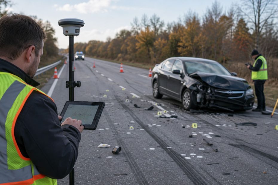
High-precision GNSS is finding a new role in vehicle crash reconstruction, where centimeter-level positioning can determine how accurately investigators document debris, tire marks, road features and other evidence before a scene changes or disappears.
Origin Forensics, a U.S. forensic consulting firm specializing in crash reconstruction, has integrated Emlid RTK rovers with Swift Navigation’s Skylark Nx RTK correction service to collect targeted survey-grade measurements at accident scenes.
The setup has demonstrated horizontal positioning accuracy below 2 cm while giving investigators a more mobile alternative to relying exclusively on terrestrial laser scanners, drones or locally deployed GNSS base stations.
RTK for Crash Reconstruction
Crash reconstruction depends heavily on establishing the precise spatial relationship between physical evidence.
Investigators may need coordinates for tire marks, debris, roadway edges, impact-related objects, vehicle rest positions and fixed reference features. Even relatively small positioning errors can become important when those measurements are later used to calculate trajectories, speeds or vehicle movement.
Origin Forensics previously relied on technologies including terrestrial laser scanning and drone photogrammetry. Both remain valuable, but they solve different parts of the mapping problem.
A laser scanner can produce an extremely detailed three-dimensional representation of a scene, but it also generates large datasets when investigators may only need a limited number of critical measurements.
Drones can rapidly map a large crash area from above, but vegetation, roadside obstacles and other objects can hide evidence from an aerial camera.
An RTK rover fills the space between those approaches.
Instead of documenting everything, an investigator can walk directly to a tire mark, piece of debris, curb, road marking or other feature and record its position with centimeter-level accuracy.
Origin Forensics is using Emlid RS2+, RS3 and Reach RX receivers as part of that workflow.
Sub-2 cm Positioning
The correction layer is provided by Swift Navigation’s Skylark Nx RTK.
Skylark Nx is a network RTK service based on virtual reference stations and atmospheric modeling rather than a correction stream generated by a base station installed at the crash scene.
Swift specifies 1 to 2 cm positioning performance for the service, while its technical specification lists 2 cm accuracy under optimal conditions and a typical time to first integer RTK fix of approximately 60 seconds. Actual performance depends on factors including the GNSS receiver, antenna, operating environment and application dynamics.
In the Origin Forensics deployment, the system has achieved horizontal accuracy below 2 cm.
That level of precision is particularly useful because evidence collected at a crash scene may eventually become part of litigation.
The objective is therefore not simply producing an attractive map. Investigators need measurements that can be checked against other datasets and supported by a repeatable technical methodology.
Drone Mapping Verification
One of the more interesting uses of the RTK rover is not replacing drone photogrammetry but verifying it.
Investigators can record fixed checkpoints such as road markings, curbs and other clearly identifiable features using the GNSS rover. Those coordinates can then serve as independent references for evaluating the spatial accuracy of aerial mapping.
The same rover can collect evidence hidden from the drone, including objects in tall grass, brush or areas with poor aerial visibility.
This creates a hybrid reconstruction workflow.
A drone captures the broad horizontal scene. Laser scanning can document complex three-dimensional geometry where necessary. RTK GNSS handles discrete evidence points and independent control measurements.
Each technology is being used where its data acquisition characteristics are strongest rather than forcing one sensor to document the entire scene.
Cloud RTK Without a Local Base
Skylark also changes the infrastructure required to obtain an RTK solution.
Traditional RTK field operations often involve establishing a local base station or connecting to an existing correction network. A cloud-delivered network RTK service allows a compatible rover to receive corrections through an internet connection without the investigator deploying a separate base receiver at each accident site.
Skylark Nx uses standard NTRIP delivery and supports standards-compliant RTK receivers. Swift lists RTCM 3.1 and RTCM 3.2 MSM5 support for the service.
Swift also says its atmospheric modeling is designed to increase usable network coverage compared with conventional single-baseline RTK, an important consideration when investigations take place far from dense urban surveying infrastructure.
For forensic teams that travel between scenes, removing the local base station can reduce equipment requirements and shorten setup time.
Why This Use Case Matters
The significance of this deployment is larger than another centimeter-accuracy demonstration.
RTK has been established for years in surveying, machine control, precision agriculture and drone mapping. Forensic reconstruction shows how the same correction infrastructure can move into specialized professional workflows where relatively few measurements may have unusually high value.
That changes the economics of precise positioning.
A crash investigator does not necessarily need millions of GNSS points. What matters is confidence in perhaps dozens or hundreds of coordinates that will later influence engineering calculations, expert testimony or legal arguments.
This is exactly the type of application where cloud RTK becomes particularly compelling.
The rover does not need to replace drones or laser scanners. Its value comes from reducing the amount of unnecessary data collection while providing independent measurements wherever other sensors have blind spots.
There is also a broader trend behind the deployment. As RTK receivers become less expensive and correction services become hardware-independent, centimeter positioning is moving beyond professional surveying crews and into industries that previously had to outsource high-accuracy geospatial work or rely on more expensive equipment.
Forensic mapping is a relatively small market compared with automotive or agriculture, but it is a strong example of how GNSS corrections can become infrastructure rather than a specialized surveying product.
About Swift Navigation
Swift Navigation is a San Francisco-based precise positioning technology company founded in 2012.
The company began by developing low-cost RTK GNSS hardware and has since shifted toward cloud-based positioning infrastructure for automotive, autonomous systems, robotics, surveying, mapping, drones and other connected devices.
Its main correction platform, Skylark, is offered in several accuracy classes. Skylark Nx RTK targets applications requiring approximately 1 to 2 cm positioning, while Skylark Cx uses PPP-RTK technology for wider-area positioning with approximately 3 to 7 cm accuracy.
As of 2026, Swift says its positioning technology powers more than 10 million vehicles and devices worldwide. Its technology has also been integrated by more than 20 automotive OEMs and Tier 1 suppliers, with deployments spanning commercial fleets containing hundreds of thousands of vehicles.
Swift’s automotive positioning technology has additionally reached ISO 26262 ASIL B functional safety certification, reflecting the company’s expansion from conventional high-precision GNSS into safety-critical positioning infrastructure for advanced driver assistance and automated driving systems.