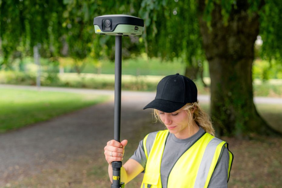
Leica Geosystems has launched the new Leica GS11 GNSS smart antenna alongside its Leica X-PAD surveying portfolio, adding dual-camera visual surveying, augmented reality stakeout, image-based point measurement and in-field verification to a receiver designed for routine professional survey work.
Announced on September 14, 2026, the GS11 sits at the center of Leica’s new X-PAD workflow strategy. Rather than positioning the receiver purely around GNSS performance, Leica is combining satellite positioning with cameras, tilt compensation, an integrated laser and software that lets surveyors see measurement and stakeout information directly against the physical site.
GS11 Adds Dual-Camera Visual Surveying
The most important technical addition is the GS11’s camera system.
The Leica GS11 I version uses dual cameras together with X-PAD to provide live visual stakeout and visual surveying. Design information, previously measured points and navigation guidance can be overlaid on the live camera image, giving the operator a direct spatial reference instead of relying only on conventional distance and direction indicators.
That has practical value on crowded construction sites, road projects and other environments where a conventional stakeout screen can require the surveyor to repeatedly translate numbers and arrows into movement on the ground.
With visual stakeout, X-PAD can show the required direction using live imagery from the GS11. The same cameras can also display previously collected information over the real site for field verification.
Image-Based Point Measurement
The cameras are not limited to navigation.
Leica says surveyors can capture groups of images and subsequently create measurement points from those images. This allows the operator to measure locations that may be difficult, obstructed or unsafe to reach directly with the survey pole.
This is particularly useful around building corners, excavations, traffic zones, structures and other locations where physically placing a GNSS pole tip on the point may be inefficient or hazardous.
It also changes the role of photography in a GNSS workflow. Instead of functioning only as documentation, captured imagery becomes part of the measurement process.
Tilt Compensation and Integrated Laser
The GS11 combines the visual system with tilt compensation, allowing points to be measured without keeping the pole perfectly vertical.
Leica also integrates a laser into the receiver. The laser provides another method for capturing points when positioning the pole tip directly on the target is impractical. Together, Leica is giving the operator three different approaches depending on site conditions: conventional pole measurement, tilted-pole measurement and indirect measurement using imagery or the laser.
Two principal GS11 configurations have been identified.
The GS11 I includes the dual cameras and supports visual surveying, image measurement, live AR stakeout, tilt compensation and laser measurement.
The GS11 T is focused on conventional GNSS surveying with tilt compensation and does not include the imaging capabilities of the GS11 I.
Dual Hot-Swappable Batteries
Leica has also addressed a less glamorous but important field issue: battery changes.
The GS11 uses two hot-swappable batteries. One battery can be removed and replaced while the receiver continues operating from the second battery, avoiding a shutdown during longer survey sessions.
For field crews working through a full shift, this is more useful than simply quoting a long nominal battery-runtime figure because it effectively removes battery replacement as a reason to interrupt a GNSS session.
X-PAD Handles Field Workflow
The GS11 has been designed specifically around Leica X-PAD field software.
X-PAD supports survey information in 2D, 3D, map and site views and can work with drawings, terrain surfaces and BIM information. With the GS11 cameras, those digital datasets can be placed into the visual context of the physical site.
The software supports a workflow that starts with importing project information and coordinate systems, continues through GNSS measurement and stakeout, and ends with field validation and reporting.
Surveyors can review measured points before leaving the site and use live augmented reality to visually compare captured information with the actual environment.
That verification step may be one of the GS11’s most valuable functions. A missed point discovered back at the office can require another trip to the project. Leica is trying to move that quality-control decision into the field while the crew is still standing at the site.
X-PAD Expands Beyond the GS11
The new X-PAD portfolio is not restricted to the GS11.
Leica says the same software environment supports the Leica GS05 GNSS smart antenna and Leica TS13 robotic total station. X-PAD Fusion extends the workflow into office processing, while Hexagon GeoCloud handles field-to-office data exchange and Hexagon SmartNet provides GNSS correction services.
X-PAD can run on compatible Android smartphones and tablets as well as Leica’s rugged CSX8 field tablet.
This creates a more integrated Leica workflow spanning GNSS, robotic total station measurements, cloud exchange and office processing without requiring every project to use Leica’s highest-end field software environment.
X-PAD Comes From GeoMax Technology
There is also an important portfolio story behind the launch.
The X-PAD software platform has long been associated with GeoMax, another Hexagon geospatial brand. Leica says those familiar X-PAD workflows are now becoming part of the Leica Geosystems portfolio, while support for both Leica and GeoMax instruments will continue. GeoMax hardware will also remain available.
Leica is positioning the resulting product families differently.
Leica Captivate remains its broad, high-capability surveying platform. Leica iCON is focused primarily on construction workflows. X-PAD is intended for a more focused group of common day-to-day surveying tasks.
Initial X-PAD portfolio availability is planned for selected countries during 2026, followed by broader availability in 2027.
Technical Specifications Still Limited
Leica’s launch information currently emphasizes workflow rather than a conventional GNSS specification table.
The company has confirmed GNSS positioning, tilt compensation, dual cameras on the GS11 I, an integrated laser and dual hot-swappable batteries. However, the current public GS11 material does not provide several figures surveyors normally use when comparing receivers, including the complete tracked-signal list, receiver channel count, published RTK horizontal and vertical accuracy, initialization specifications, weight and environmental protection rating.
Those figures will be important when the GS11 is evaluated directly against Leica’s existing GS receivers and competing visual GNSS systems.
Why the GS11 Matters
The GS11 is interesting because Leica is treating the camera as part of the measurement interface rather than simply adding one to a GNSS receiver.
Tilt compensation has already reduced the need to level a GNSS pole. Visual stakeout reduces another part of the process: mentally translating abstract navigation information into movement across the actual site. Image measurement then extends the receiver beyond points that can physically be occupied with the pole.
The most useful feature may ultimately be field verification. Survey companies lose far more time from returning to a site for one missing or questionable measurement than from waiting a few additional seconds for individual GNSS observations. Putting measured data directly over live imagery gives the crew a straightforward way to check completeness before packing up.
The unanswered question is where Leica will position the GS11 technically and financially relative to its higher-end GNSS equipment. The visual workflow is convincing, but receiver specifications and pricing will determine whether it becomes primarily a simplified everyday instrument or a serious alternative for crews that currently use Leica’s more advanced GNSS platforms.
About Leica Geosystems
Leica Geosystems is a Swiss measurement and geospatial technology company headquartered in Heerbrugg, Switzerland, with a history extending more than 200 years. Its product portfolio covers GNSS surveying, total stations, reality capture, laser scanning, construction measurement, monitoring, mapping and related software and cloud services.
Leica Geosystems is part of Hexagon, the Stockholm-listed measurement technology group.
Following major portfolio changes announced by Hexagon in 2026, the group describes its continuing operations as having approximately 16,000 employees across 50 countries and annual net sales of about €3.7 billion. Hexagon reported second-quarter 2026 operating net sales of €1.05 billion, up 12% organically, with EBITAC of €255.1 million and a 24.3% EBITAC margin.
Source: www.leica.com