NV5 will demonstrate how geospatial analytics, remote sensing and augmented reality can help electric utilities identify vegetation hazards, prioritize maintenance and manage tree-related risks to power infrastructure at the Trees & Utilities Conference in Portland, Oregon, September 22-24, 2026.
The company will present its vegetation management solutions at Booth 1101, including an interactive augmented reality (AR) demonstration that places vegetation risk information directly into the surrounding physical environment.
NV5 will also participate in a technical session with electric utility ComEd, examining how geospatial data can support vegetation maintenance decisions while accounting for the needs of communities served by electrical infrastructure.
LiDAR Vegetation Risk Assessment
A central element of NV5’s presentation will be the use of geospatial data to assess vegetation conditions around overhead power lines and other utility assets.
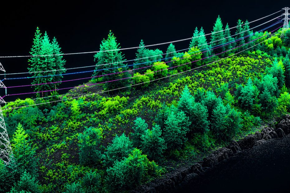
Remote sensing technologies, including Light Detection and Ranging (LiDAR), allow utilities to create detailed three-dimensional representations of trees, transmission corridors, distribution lines and surrounding terrain.
Analyzing these datasets enables vegetation management teams to identify several categories of potential hazards:
- Fall-in risk: Trees outside the immediate clearance zone that could strike electrical infrastructure if they fall.
- Grow-in risk: Vegetation that may encroach on required electrical clearances as it continues to grow.
- Overhang risk: Branches extending above power lines or other infrastructure that could cause damage or electrical faults.
- Ground clearance: The vertical separation between vegetation, terrain and electrical infrastructure.
These measurements provide a basis for prioritizing inspection and maintenance activities across large utility service territories.
NV5’s vegetation management capabilities also cover wildfire risk mitigation, integrated vegetation management (IVM), asset conflation and compliance with applicable North American Electric Reliability Corporation (NERC) requirements.
Asset conflation is particularly relevant when utilities maintain separate geographic information system (GIS), asset inventory and inspection databases. Combining records from these sources can help associate vegetation hazards with the correct infrastructure assets and maintenance locations.
However, identifying a vegetation hazard through remote sensing does not automatically establish its operational severity. Utilities must also consider tree condition, species, growth rates, local weather exposure and the consequences of a potential infrastructure failure.
Augmented Reality for Utility Crews
NV5 will demonstrate a handheld augmented reality application that overlays vegetation management information onto the environment surrounding the Oregon Convention Center.
Instead of interpreting risk assessments exclusively through GIS maps or desktop visualization software, conference attendees will be able to view fall-in, grow-in and overhang risk information in a real-world setting.
The demonstration is intended to show how geospatial analysis can be translated into information that vegetation management personnel can use during field operations.
NV5 plans to make the demonstration available outside the convention center each morning. A guided outdoor walkthrough is also scheduled for September 23 at 4 p.m., with participants gathering at Booth 1101.
For utility crews, an application of this type could make it easier to relate remotely identified hazards to individual trees, branches and nearby electrical infrastructure.
The practical effectiveness of an AR-based system, however, depends on several technical factors, including positioning accuracy, the quality and age of the underlying vegetation data, and the reliability of alignment between digital models and physical objects.
The announced conference demonstration will illustrate NV5’s visualization capabilities, but it should not be interpreted as independent validation of field positioning accuracy or operational performance.
ComEd Vegetation Management Strategy
NV5 and ComEd will examine how remote sensing and geospatial analytics can support vegetation management programs that consider both infrastructure reliability and local community needs.
The session, titled “Where Data Meets Community: A New Approach to Vegetation Management,” will take place on September 23, from 2:15 p.m. to 2:55 p.m., in Rooms B113-114.
The speakers will include Andrew Brenner, NV5’s vice president for Solution Engineering; Jacob Hall, NV5 account manager; and Nick Day, principal program manager at ComEd.
The discussion will address how Equity Investment Eligible Communities (EIEC) are identified and monitored using socioeconomic indicators and other relevant metrics.
The session will also cover the use of LiDAR data and enhanced tree-trimming strategies to improve maintenance planning, along with a replacement tree program developed through cooperation with the Arbor Day Foundation.
This approach introduces an additional dimension to utility vegetation management. Rather than assigning maintenance priorities exclusively according to physical clearance measurements, utilities can combine infrastructure risk assessments with information about the communities affected by maintenance activities.
For example, geospatial analysis can help identify areas where vegetation-related outages may affect critical infrastructure or where repeated tree removal could have significant environmental and community consequences.
Such information can support more transparent maintenance planning, although the underlying electrical safety requirements must remain central to operational decisions.
Technical Perspective
The most significant aspect of NV5’s presentation is the connection between remote sensing, geospatial analytics and field-level decision-making.
LiDAR can identify potentially hazardous vegetation across extensive utility networks, but the operational value of that information depends on how accurately it is converted into actionable maintenance priorities.
Augmented reality offers a potentially useful interface for that process, particularly when field crews need to identify individual hazards within complex utility corridors.
However, the technology should be assessed against measurable outcomes rather than visualization capabilities alone. Detection accuracy, data update frequency, positioning reliability, inspection costs and the number of vegetation-related incidents prevented are more meaningful indicators of its practical value.
NV5’s approach illustrates how utility vegetation management can move toward more systematic, data-driven maintenance planning. Its long-term effectiveness will depend on the ability to integrate geospatial intelligence into existing utility workflows while demonstrating measurable improvements in infrastructure reliability and operational efficiency.
About NV5
NV5 is a global provider of geospatial solutions, engineering services and software for infrastructure, utilities, environmental management and other technical applications.
Its geospatial portfolio includes remote sensing, data acquisition, geospatial analytics, enterprise GIS, software development and AI-based analysis.
The company uses technologies including LiDAR, computer vision, deep learning and predictive analytics to support infrastructure assessment, resource management and risk identification.
NV5 became part of TiC Solutions following the completion of its acquisition on August 4, 2025. The transaction involved approximately $1.7 billion in aggregate consideration.
The combined organization was established with more than $2 billion in annual revenue, bringing together NV5’s engineering and geospatial operations with Acuren’s asset integrity, inspection and testing services.
According to TiC Solutions’ 2025 annual financial reporting, NV5 contributed approximately $431.4 million in revenue from the acquisition date through December 31, 2025. This figure represents a partial year of operations within the combined company, rather than NV5’s full-year revenue.
Trees & Utilities 2026: Dates and Location
The Trees & Utilities Conference will take place September 22-24, 2026, at the Oregon Convention Center, located at 777 NE Martin Luther King Jr. Blvd., Portland, Oregon.
The event is expected to bring together more than 1,500 utility professionals, vegetation management specialists, urban foresters and environmental industry representatives.
NV5 will present its geospatial vegetation management solutions at Booth 1101. The company’s augmented reality demonstration will be available during exhibition hours, with a guided outdoor walkthrough scheduled for September 23 at 4 p.m.
The conference will focus on utility vegetation management, electrical infrastructure reliability, wildfire risk mitigation and sustainable urban forestry.
Source: www.nv5.com