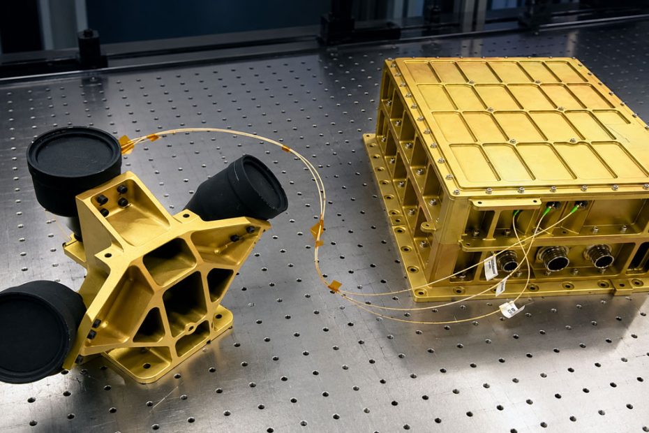
NASA’s Navigation Doppler Lidar is preparing for another trip to the Moon after its first lunar demonstration delivered highly accurate altitude and velocity measurements during Intuitive Machines’ historic IM-1 mission in 2024.
The laser-based navigation system, known as NDL, has now been integrated with Astrobotic’s Griffin-1 lunar lander, which is scheduled to launch in late 2026. The upcoming mission will give NASA another opportunity to evaluate the technology during an operational descent, this time as part of a landing architecture designed for the challenging lunar south polar environment.
NDL Lunar Test Results
Navigation Doppler Lidar was developed at NASA’s Langley Research Center as an alternative to conventional radar-based velocity and altitude sensing.
The system directs multiple laser beams toward the surface below a spacecraft. By measuring the Doppler frequency shift of the reflected light, NDL can calculate the vehicle’s velocity relative to the ground. The timing of the returning signals provides altitude information.
NASA says the technology can determine spacecraft velocity with precision measured in centimeters per second while providing highly accurate altitude information during descent.
Its first lunar demonstration came aboard Intuitive Machines’ Odysseus lander, which reached the Moon on February 22, 2024.
Although NDL had originally been installed as a backup navigation instrument, problems with Odysseus’ primary navigation sensors created an unexpected opportunity for the laser system to play a larger role.
Flight controllers attempted to use the NDL measurements during the descent. A software integration issue ultimately prevented the lander’s guidance system from incorporating the information, meaning NDL was not responsible for controlling the final landing trajectory.
The instrument itself, however, performed successfully.
Post-flight analysis found that its altitude and velocity measurements closely tracked modeled values. Lunar terrain features, including craters, were also identifiable in the recorded lidar data and could be compared with existing digital elevation maps.
The results showed agreement of roughly 5 meters for range measurements and about 0.5 meters per second for velocity measurements, providing an important flight validation of the underlying navigation concept.
How Navigation Doppler Lidar Works
NDL performs a job similar to Doppler radar but replaces radio-frequency energy with laser light.
The architecture developed at NASA Langley uses several laser beams transmitted toward the planetary surface at different angles. Reflected light returns to the instrument, where changes in frequency and signal timing are analyzed.
This allows the navigation computer to derive multiple pieces of information simultaneously, including ground-relative velocity and altitude.
NASA developed the system specifically because precision landing becomes increasingly important as missions move away from large, relatively forgiving landing zones.
Future lunar spacecraft may need to place scientific instruments, cargo or crew within much smaller areas surrounded by slopes, rocks, craters and other terrain hazards.
NDL does not identify those hazards itself. Instead, it provides the highly accurate motion data required by the guidance system while separate terrain-relative navigation and hazard-detection systems determine where the spacecraft should land.
That separation is important. NDL is fundamentally a navigation sensor rather than a terrain imaging instrument.
Griffin-1 Gets NASA NDL
The next major test will take place aboard Astrobotic’s Griffin-1.
Astrobotic confirmed in April 2026 that Navigation Doppler Lidar had been integrated into the lander. Griffin combines NDL with terrain-relative navigation and hazard-detection technology to support autonomous landing operations.
The spacecraft is being prepared for a mission to the lunar south polar region, where long shadows, dramatic lighting contrasts and uneven terrain make navigation particularly demanding.
Astrobotic unveiled the flight lander in June and said the mission is scheduled for launch in late 2026. The company describes Griffin as an infrastructure-class lunar lander intended to transport increasingly large payloads to the surface.
The mission is part of NASA’s Commercial Lunar Payload Services program, which contracts private companies to transport scientific instruments and technology demonstrations to the Moon.
NASA has also described Griffin-1 as part of its broader lunar exploration architecture.
Why Lidar Can Beat Radar
Laser navigation offers several potential advantages over radar when operating around airless planetary bodies.
Because laser wavelengths are dramatically shorter than the radio wavelengths normally used by radar, lidar systems can achieve highly precise measurements using relatively compact optical hardware.
The Moon is also particularly suitable for lidar because it has essentially no atmosphere. There are no terrestrial clouds or dense atmospheric layers that could significantly interfere with the laser path during descent.
Integration can also be simpler in some spacecraft configurations, potentially reducing mass, power requirements and development complexity.
These advantages become increasingly valuable for commercial lunar landers where every kilogram of payload capacity and every watt of electrical power carries a direct mission cost.
Psionic Commercializes NASA Lidar
NDL is also becoming an example of how NASA-developed technology can move into commercial products.
NASA licensed the technology to Virginia-based Psionic in 2016. The company subsequently developed its own Psionic Navigation Doppler Lidar, or PNDL, using the NASA architecture as its technological foundation.
According to NASA, Psionic’s newer hardware is less than half the size and weight of the original system while offering expanded operating range, lower power requirements and additional functionality.
More recent development work has produced a fourth-generation system capable of simultaneously measuring range and velocity in four directions. The resulting data can be used to estimate ground speed, altitude, roll and pitch.
NASA has also flight-tested Psionic hardware aboard research aircraft as the technology moves toward additional space and terrestrial applications.
NDL Could Become Standard Lunar Hardware
The most important part of the 2024 mission may not be that NDL demonstrated unusually high measurement accuracy. Precision laser velocimetry has already been proven extensively in terrestrial testing.
What matters more is that the system produced useful data in the actual lunar environment.
Spaceflight technologies frequently perform well during controlled testing but encounter unexpected thermal, optical, vibration or integration problems once installed on operational spacecraft. NDL has now crossed part of that gap.
Its next challenge is system-level integration.
The Odysseus experience demonstrated that a sensor can perform perfectly while still failing to contribute to the mission if its data cannot reach or be interpreted by the guidance computer. Griffin-1 therefore represents a more meaningful test than simply repeating the measurement experiment.
If NDL data is successfully incorporated into closed-loop guidance during Griffin’s descent, the technology could move from experimental payload toward standard landing equipment.
That could be particularly significant as commercial companies attempt more frequent lunar missions. Standardized precision navigation sensors could lower engineering risk and reduce the amount of custom navigation hardware required for each new lander.
The technology is therefore developing into something larger than a NASA research experiment. It is becoming part of an emerging commercial ecosystem for autonomous planetary landing.
About NASA
NASA was established in 1958 and remains the United States’ primary civil space and aeronautics agency. Its organization includes 10 major centers and facilities and approximately 14,000 civil servants working across more than 150 occupational fields.
Navigation Doppler Lidar was developed at NASA’s Langley Research Center in Hampton, Virginia, with support from several Space Technology Mission Directorate programs. The technology received NASA’s Commercial Invention of the Year award in 2022 and has since been transferred to industry through the agency’s technology licensing program.
NASA’s enacted FY2026 funding totals about $24.8 billion according to the agency’s FY2027 budget documentation. Its lunar programs increasingly combine NASA-developed technology with commercial spacecraft supplied through initiatives such as Commercial Lunar Payload Services.
SEO Meta Description: Discover how NASA’s Navigation Doppler Lidar proved its accuracy on the Moon and why its 2026 Griffin-1 flight could make laser navigation a key technology for future lunar landings.