South Tyrolean aerial survey provider Alto Drones has completed a high resolution topo bathymetric mapping project along Austria’s Piesting River, using a dual sensor airborne LiDAR configuration built around RIEGL’s VUX-120 and VQ-840-G systems. The project marks a practical example of how combined topographic and bathymetric data acquisition can streamline hazard zone planning and flood protection workflows.
Commissioned as part of a federal hazard mitigation program, the survey provides a continuous digital representation of both terrain and riverbed conditions across more than 60 kilometers of river corridor.
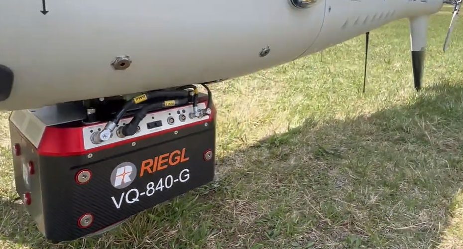
Dual sensor LiDAR workflow enables seamless riverbed and terrain mapping in a single flight
The project relied on a helicopter based platform equipped with two complementary LiDAR sensors and an RGB nadir camera. The RIEGL VUX-120 handled topographic data capture over land, while the VQ-840-G was dedicated to bathymetric measurements, penetrating the water column to map submerged features.
This dual sensor approach eliminates the traditional gap between land and underwater datasets, which often require separate missions and complex post processing alignment. By capturing both domains simultaneously, Alto Drones achieved a consistent dataset with reduced spatial mismatch and improved efficiency.
Flight operations were conducted at approximately 200 meters altitude under favorable seasonal conditions including low water levels, minimal vegetation cover, and limited snow presence. These factors are critical for bathymetric LiDAR performance, where water clarity and surface conditions directly impact penetration depth and signal return quality.
RIEGL VUX-120 and VQ-840-G specifications support high density multi environment data capture
The RIEGL VUX-120 is designed as a high performance airborne laser scanner optimized for helicopter and UAV integration. It supports high pulse repetition rates and dense point cloud generation, making it suitable for detailed terrain modeling, infrastructure mapping, and corridor surveys. Its capability to operate efficiently at varying altitudes allows operators to balance coverage and resolution depending on mission requirements.
The VQ-840-G, in contrast, is a specialized topo bathymetric LiDAR system that uses a green wavelength laser to penetrate water surfaces. This enables accurate measurement of riverbeds and shallow coastal zones, provided that water turbidity and environmental conditions remain within operational limits. The system is engineered to capture both surface and subsurface returns, enabling the creation of continuous elevation models across land water boundaries.
Together, these sensors create a complementary dataset where the VUX-120 ensures high fidelity terrain capture, while the VQ-840-G extends coverage into submerged areas without requiring separate survey campaigns.
LiDAR data processing pipeline produces DTM and DSM for flood risk modeling
Data processing was carried out using RIEGL’s proprietary software ecosystem. Trajectory computation and raw data handling were performed in RiPROCESS, followed by point cloud registration and georeferencing based on reference surfaces.
A critical step in bathymetric LiDAR workflows is refraction correction, which compensates for the change in light speed as the laser passes from air into water. In this project, correction was handled in RiHYDRO using measured water surface data, ensuring accurate positioning of underwater points.
The final deliverables included both a Digital Terrain Model (DTM) and a Digital Surface Model (DSM), representing the first continuous dataset of this river section that integrates dry land and submerged topography at this scale.
Topo bathymetric LiDAR data improves flood protection planning and hazard zone management
From an application standpoint, the dataset provides a detailed baseline for monitoring river morphology, sediment transport, and channel changes over time. This is particularly relevant for flood risk modeling, where accurate representation of river geometry directly influences simulation outcomes.
By capturing the full river corridor in a single coordinated dataset, planners and public authorities gain a more reliable foundation for designing flood protection measures, managing land use, and assessing long term environmental changes.
About RIEGL
RIEGL is an Austria based LiDAR manufacturer founded in 1978, with headquarters in Horn, Lower Austria. With more than four decades of experience in laser scanning development, the company has established itself as a key player in high performance airborne and bathymetric LiDAR systems.
Today, the RIEGL Group employs over 300 people worldwide, including a strong concentration of engineering and technical specialists at its Austrian headquarters. The company maintains a global presence with offices in the United States, Japan, China, Australia, Canada, and the United Kingdom, supported by an extensive international partner network.
RIEGL’s main facility includes more than 40,000 square feet of workspace dedicated to research, development, production, and training, along with over 350,000 square feet of outdoor testing area used for real world system validation.
The company specializes in full waveform LiDAR technology and develops solutions for airborne, mobile, terrestrial, UAV based, and industrial applications. Its systems are widely deployed in geospatial surveying, infrastructure monitoring, environmental analysis, and hydrographic mapping worldwide.


