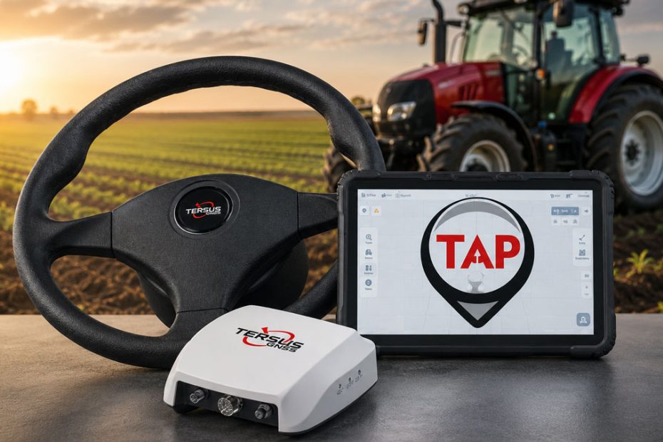
Tersus GNSS has expanded the growing market of retrofit guidance systems with the AG993, a modular autosteer solution designed to maintain centimeter level positioning even when conventional RTK corrections become unavailable. The new system combines standard RTK capability with the company’s proprietary TAP (Tersus Advanced Positioning) satellite correction service, providing an alternative correction source through L band satellites rather than relying solely on cellular networks or local base stations.
The AG993 has also been added to the Future Farming Autosteer Retrofit Kits Catalogue, highlighting its position among commercially available aftermarket guidance solutions.
Satellite Correction Backup Targets RTK Reliability
One of the most notable aspects of the AG993 is its ability to automatically transition between correction sources without interrupting field operations.
Under normal conditions, the system operates using RTK corrections for guidance accuracy better than 2.5 cm. If the RTK connection is temporarily interrupted, TAPFill automatically switches to the satellite based TAP correction service while preserving the same coordinate reference framework. This minimizes line drift and allows operators to continue working until RTK connectivity returns.
Unlike traditional RTK systems that depend on mobile internet coverage or nearby base stations, TAP receives correction data directly from L band satellites. For farms located in remote areas with unreliable cellular service, this provides an additional layer of operational continuity during planting, spraying, or tillage.
Should GNSS positioning quality fall below acceptable limits or satellite reception be lost entirely, the software alerts the operator and requires autosteer to be disengaged until positioning accuracy is restored.
Designed for Broad Vehicle Compatibility
The AG993 follows the modular architecture increasingly common among aftermarket steering systems.
The standard package includes the GC30 Guidance Controller, TC120 Android tablet, TES30 electric steering motor, steering wheel, vehicle specific mounting hardware, wiring harnesses, camera, and power switch assembly.
According to Tersus GNSS, the system is compatible with more than 90% of agricultural vehicles, provided suitable steering column geometry, electrical supply, installation space, and GNSS antenna placement are available.
Because the core hardware is modular, it can theoretically be transferred between compatible machines. However, each installation requires new mounting hardware where necessary, complete calibration, and vehicle specific parameter adjustments.
Precision Guidance Across Multiple Field Patterns
The AG993 supports field operations at speeds ranging from 0.2 km/h to 30 km/h, while also maintaining guidance at extremely slow speeds down to 0.1 km/h, which can be valuable for specialty crop applications or precision operations.
Available guidance modes:
- Straight AB lines.
- Curved guidance lines.
- Boundary following.
- Four automatically generated smart path patterns.
- Automatic headland U turns.
The receiver tracks all major global satellite constellations, including GPS, GLONASS, Galileo, BeiDou including BDS 3, QZSS, SBAS, and IRNSS, together with the dedicated L band correction signal required for TAP.
The ruggedized hardware is built for agricultural environments. Both the GC30 controller and TC120 10.1 inch Android tablet carry an IP67 protection rating, while the TES30 steering motor is rated IP55. Tersus is also developing a larger 12 inch display for future releases.
ISOBUS Development Continues
While today’s AG993 focuses primarily on vehicle guidance, Tersus says broader machine integration is already under development.
Future software releases are expected to introduce ISOBUS Virtual Terminal and Task Controller compatibility, creating the foundation for section control and implement management on sprayers and seed drills.
The company currently schedules major software releases approximately every six months, with maintenance updates potentially delivered each quarter to align with agricultural operating seasons.
Open Source Strategy Could Expand Adoption
An interesting aspect of Tersus’ long term roadmap is its intention to develop integration with the AgOpenGPS ecosystem.
Rather than positioning the AG993 exclusively as a closed commercial platform, the company plans to allow the GC30 controller to interface with the popular open source precision farming community. If successful, users could benefit from Tersus hardware and positioning technology while leveraging community developed software features and integrations.
This approach differs from many established autosteer manufacturers, which generally rely on proprietary software ecosystems.
Looking Beyond Guidance
Tersus also views the AG993 as a stepping stone toward higher levels of agricultural automation.
According to the company, future autonomous systems will increasingly combine GNSS positioning with multiple sensing technologies including cameras, LiDAR, radar, ultrasonic sensors, IMUs, vehicle CAN bus data, implement sensors, and edge AI processing. These technologies would support obstacle detection, automated path adjustment, implement monitoring, remote diagnostics, and supervised autonomous operation.
The company also expects regulatory compliance, cybersecurity, geofencing, emergency stop functions, remote monitoring, and permission management to become increasingly important as agricultural machines move toward supervised autonomy.
Pricing
The AG993 carries an estimated retail price ranging from approximately US$4,000 to US$8,000, depending on market, dealer, installation requirements, and selected configuration. Optional licensing is available for TAP satellite correction subscriptions, while advanced functions such as automatic headland U turns are currently included without additional feature unlocks.
About Tersus GNSS
Tersus GNSS is a high precision positioning technology company headquartered in Shanghai, China. Founded in 2014, the company develops GNSS receivers, inertial navigation systems, correction services, machine control solutions, and precision agriculture products for customers worldwide. Its portfolio spans surveying, construction, marine, unmanned systems, and agricultural guidance, with products distributed through an international dealer network across dozens of countries.