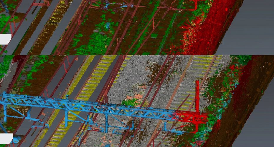
Leica Geosystems has officially introduced a new AI driven image beautification capability inside Pegasus OFFICE 2026.1, targeting one of the most persistent challenges in mobile mapping and digital reality capture workflows: improving visual clarity and readability inside dense infrastructure datasets.
The new functionality automatically enhances captured imagery and point cloud visualization by improving brightness, sharpness, contrast, and overall scene clarity. Early preview examples released by Leica show a noticeable reduction in visual noise across railway corridor scans, with vegetation, rail ballast, infrastructure edges, and structural elements becoming significantly easier to distinguish.
For operators working with railways, highways, utilities, urban infrastructure, and digital twin projects, this may appear cosmetic at first glance. In practice, however, visual readability has become increasingly important as mobile mapping datasets continue growing in size and complexity.
Better Visualization for Large Scale Mapping
Modern mobile mapping systems generate enormous volumes of data. A single corridor mapping mission can now produce terabytes of imagery, LiDAR point clouds, and geospatial metadata.
One of the hidden problems within that process is operator fatigue during post processing. Engineers and GIS specialists often spend hours manually reviewing datasets where shadows, inconsistent lighting, motion blur, weather conditions, reflective surfaces, or vegetation clutter make interpretation more difficult.
Leica’s new AI enhancement system appears designed to reduce that friction.
Based on the first released examples, the software intelligently separates infrastructure objects from environmental clutter while improving tonal consistency across the scene. Railway sleepers, ballast profiles, overhead line structures, and corridor boundaries become visually cleaner without dramatically altering the underlying geometry.
That distinction matters.
In professional surveying and mapping workflows, aggressive AI filtering can sometimes introduce false confidence or visual artifacts that distort engineering interpretation. Leica seems to be taking a more conservative approach focused on readability enhancement rather than synthetic reconstruction.
AI Is Becoming a Core Layer in Geospatial Software
The release also reflects a broader industry trend. Artificial intelligence is rapidly moving from experimental geospatial research into practical production software.
Over the past two years, AI integration inside reality capture platforms has accelerated across several areas:
- Automatic object classification.
- Point cloud segmentation.
- Feature extraction.
- Change detection.
- Noise filtering.
- Semantic scene understanding.
- Automated asset inventory generation.
Leica’s implementation focuses specifically on visual optimization, but it signals something larger. Mobile mapping software is increasingly evolving from raw data management platforms into intelligent interpretation systems.
That transition could become especially important as governments and infrastructure operators push toward large scale digital twin deployment.
Railway and Infrastructure Applications
Railway mapping stands out as one of the strongest use cases for the new release.
Rail corridors create extremely demanding scanning environments due to repeating geometry, reflective metal surfaces, overhead wires, dense vegetation transitions, and rapidly changing light conditions. AI assisted enhancement can improve visibility for asset inspection teams reviewing:
- Track geometry conditions.
- Vegetation encroachment.
- Signal infrastructure.
- Catenary systems.
- Drainage corridors.
- Safety clearances.
The before and after examples published by Leica suggest the company is specifically targeting these operational review scenarios rather than purely marketing oriented visualization.
Industry Perspective on the Release
What makes this update interesting is not simply the sharpening effect itself. The bigger story is that geospatial software companies are beginning to treat visualization quality as a productivity feature instead of just a presentation feature.
That shift is important.
As reality capture projects scale into national infrastructure programs and persistent digital twins, human interpretation speed becomes a real operational bottleneck. Cleaner visual datasets reduce cognitive load during inspection, QA review, and engineering validation.
The geospatial industry has historically focused heavily on sensor accuracy, positioning precision, and point density. Those remain critical. But software usability is increasingly becoming the differentiator between platforms.
Leica appears to understand that.
If the AI enhancement remains computationally efficient and avoids introducing synthetic distortions into engineering grade data, Pegasus OFFICE 2026.1 could become particularly attractive for rail, transport, and utility operators managing large mobile mapping archives.
Leica Geosystems Market Position
Leica Geosystems remains one of the most influential companies in the global surveying and geospatial technology sector. Founded in Switzerland and now operating under Hexagon AB, the company has built a major presence across surveying, GNSS positioning, mobile mapping, LiDAR scanning, machine control, and reality capture technologies.
Hexagon operates in more than 50 countries worldwide and serves customers across construction, transportation, mining, utilities, defense, and infrastructure sectors. Leica’s Pegasus mobile mapping portfolio has become particularly well known in high precision corridor mapping, smart city modeling, and transportation asset management projects.