GEODNET brought its expanding global RTK correction network, a $695 handheld GNSS receiver, and an autonomous security drone to INTERGEO 2026 in Munich, Germany. The company’s central proposition was affordable centimeter-level positioning without requiring customers to install and maintain their own GNSS reference stations.
Held September 15–17, INTERGEO 2026 brought together surveying, geospatial technology, and positioning industry professionals. GEODNET demonstrated its GEO-MEASURE handheld receiver and GEO-SWARM autonomous drone system, both designed to operate using the company’s decentralized GNSS infrastructure.
The most significant commercial announcement was the combination of RTK corrections starting at $40 per month or $400 annually and a compact multi-frequency receiver priced at $695, including a one-year correction subscription. These offerings could make high-precision GNSS positioning more accessible to smaller surveying companies, GIS specialists, agricultural operators, and autonomous equipment developers.
GEODNET RTK Network: $40 Monthly Corrections
GEODNET’s network now comprises more than 22,000 GNSS reference stations worldwide. Unlike conventional positioning networks operated by a single surveying authority or commercial service provider, GEODNET relies on a decentralized infrastructure of independently deployed stations.
These stations collect satellite observations that are processed into corrections for compatible GNSS receivers. The service supports real-time positioning through NTRIP, allowing receivers to obtain correction streams over an internet connection.
According to GEODNET’s technical documentation, the network supports GPS, GLONASS, Galileo, BeiDou, QZSS, and IRNSS/NavIC. Its documented delivery architecture includes RTCM correction messages, NTRIP v1.0 connectivity, and correction updates at 1 Hz. The company reports achievable RTK precision of approximately 1–2 cm under suitable conditions.
The subscription structure is straightforward: $40 for monthly access or $400 for a year, with each standard subscription covering one device. The annual plan represents a $80 saving compared with 12 monthly payments.
Importantly, the subscription does not eliminate the need for compatible GNSS hardware, internet connectivity, and adequate reference network coverage. Actual positioning quality depends on local station availability, satellite visibility, correction latency, atmospheric conditions, and multipath interference.
GEO-MEASURE: $695 Handheld RTK Receiver
The second major attraction was GEO-MEASURE, a portable GNSS RTK receiver developed by HYFIX Spatial Intelligence for use with the GEODNET network.
Priced at $695, the device integrates a multi-frequency GNSS engine, antenna, wireless connectivity, and rechargeable battery into a single handheld enclosure. It connects to a smartphone through Bluetooth Low Energy and operates with the GEO-MEASURE mobile application.
The receiver is designed for point collection, GIS data acquisition, construction measurements, agricultural field mapping, and other outdoor positioning tasks.
According to the manufacturer’s technical data sheet, GEO-MEASURE supports four major GNSS constellations, multiple signal bands, and up to 1,040 tracking channels.
GEO-MEASURE Specs
| Specification | Manufacturer’s Data |
|---|---|
| GNSS constellations | GPS, GLONASS, Galileo, BeiDou |
| Additional signals | QZSS, IRNSS L5 |
| GNSS channels | Up to 1,040 |
| RTK horizontal accuracy | 8 mm + 1 ppm RMS |
| RTK vertical accuracy | 15 mm + 1 ppm RMS |
| Standalone horizontal accuracy | 1.5 m RMS |
| RTK initialization reliability | Greater than 99.9% |
| RTK convergence time | Less than 5 seconds |
| Cold start | Less than 29 seconds |
| Hot start | Less than 2 seconds |
| Correction format | RTCM v3.x, MSM included |
| Positioning output | NMEA 0183, 10 Hz |
| Wireless connectivity | Bluetooth 4.2, Wi-Fi 802.11b/g/n |
| Battery | 7.2 V, 6,800 mAh lithium-ion |
| Battery endurance | Up to 24 hours of active operation |
| Charging | USB-C PD, approximately 4 hours typical |
| Dimensions | 71 × 71 × 140 mm |
| Weight | 430 g |
| Protection | IP67 |
| Operating temperature | -30°C to +65°C |
| Mounting thread | 5/8-11 inch |
The manufacturer’s stated 8 mm horizontal precision is particularly noteworthy at this price point. However, this figure represents an RTK measurement specification rather than a guarantee of 8 mm absolute positional accuracy in every environment.
The distinction matters for professional surveying. Receiver precision, absolute coordinate accuracy, antenna setup, network datum, and site conditions all contribute to the final measurement quality.
The device also features a 5/8-inch survey pole mounting thread, allowing operators to use it with conventional surveying accessories. Its IP67 enclosure and specified resistance to a 2-meter drop when mounted on a survey pole make it suitable for demanding field environments.
Smartphone-Based GNSS Surveying
GEO-MEASURE replaces much of the traditional receiver-and-controller arrangement with a smartphone-centered workflow.
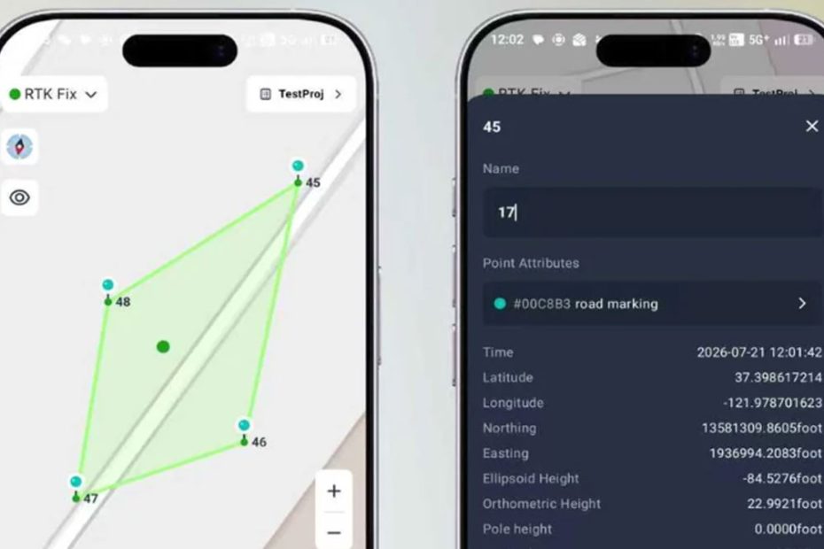
Through the GEO-MEASURE application, users can connect to the receiver, establish an RTK correction connection, collect positioning data, manage projects, and export measurements. The system is designed to simplify basic surveying and GIS operations without requiring a dedicated field controller.
A one-year GEODNET correction subscription is included with the receiver. For a buyer already planning to purchase a $400 annual correction subscription, that bundled service materially changes the economics of the hardware purchase.
The advertised package includes a protective Pelican case, USB-C cable, and documentation.
Nevertheless, smartphone compatibility, supported export formats, coordinate reference system handling, and compatibility with established professional surveying software remain important considerations before adopting the device for regulated or high-accuracy workflows.
GEO-SWARM: $2,000 Autonomous Security Drone
GEODNET also demonstrated GEO-SWARM, an autonomous drone-in-a-box system developed by HYFIX Spatial Intelligence for property surveillance and automated aerial monitoring.
The system integrates a compact drone, an automated charging dock, RTK positioning, and a mobile application. It is designed to perform predefined patrols, transmit live video, return to its docking station, and recharge without requiring continuous manual control.
The manufacturer’s published specs:
- Weight: Under 250 g
- Video: Live 4K aerial monitoring
- Flight endurance: Up to 15 minutes
- Operating range: Up to 1 km
- Positioning: GEODNET centimeter-level RTK
- Flight operations: Autonomous takeoff, patrol, landing, and charging
- Compliance: Advertised as NDAA-compliant
- Price: $2,000, with a $500 pre-order deposit
GEO-SWARM remains a pre-order product, with initial deliveries estimated for late 2026 or early 2027. Final availability and specifications remain subject to change.
The integration of RTK positioning is especially relevant to autonomous docking. Repeatable positioning could help the aircraft navigate predetermined routes and return to a relatively small landing area, although reliable docking also depends on obstacle detection, local sensing, flight control, and environmental conditions.
For GEODNET, the drone represents an expansion beyond the traditional surveying market. The same correction infrastructure can support applications ranging from aerial inspection and agricultural monitoring to mobile robotics and autonomous security systems.
Can Affordable RTK Challenge Traditional GNSS Services?
The most important development at INTERGEO was not an individual receiver or drone. It was GEODNET’s effort to lower the combined cost of precision positioning hardware and correction services.
A $695 receiver bundled with one year of RTK access creates a relatively inexpensive starting point for organizations that need centimeter-level GNSS data but cannot justify a larger investment in surveying hardware.
However, lower hardware prices do not automatically make two surveying systems technically equivalent. Professional users must still consider antenna performance, coordinate system support, calibration procedures, field software, measurement traceability, and integration with existing workflows.
Network geography is equally important. A service operating across hundreds of countries can still have gaps in local reference station density. For RTK users, a nearby, well-maintained station and a dependable correction stream can matter more than the total number of stations worldwide.
GEODNET’s architecture also introduces a different infrastructure model. Distributed station ownership can accelerate geographical expansion, but maintaining consistent station coordinates, equipment quality, monitoring, and long-term service reliability becomes a central technical challenge.
The competitive significance lies in the possibility of making high-precision positioning a relatively low-cost operating service rather than a substantial infrastructure investment. For GIS mapping, agricultural applications, drone operators, and small surveying businesses, this could be more consequential than another incremental improvement in GNSS receiver specifications.
GEODNET still needs to demonstrate that its pricing advantage can be sustained alongside dependable regional coverage, professional support, and consistent positioning performance. Independent field comparisons with established RTK networks would provide stronger evidence of how its service performs beyond controlled demonstrations.
About GEODNET
GEODNET is a decentralized GNSS positioning network launched in 2022, with Mike A. Horton identified as its project creator. The network uses community-operated reference stations and a decentralized physical infrastructure model, rewarding participating station operators through its GEOD token ecosystem.
As of October 2026, GEODNET reports more than 22,000 reference stations worldwide, live coverage in more than 150 countries, correction latency below one second, and centimeter-level positioning capability. Its published company milestones also report approximately $10 million in annual revenue for 2025, although those figures are company-reported rather than independently audited in this article.
The company’s technology serves surveying, GIS, precision agriculture, construction, drones, robotics, and autonomous navigation. Its commercial ecosystem includes GNSS corrections, positioning hardware, developer interfaces, and partner-built autonomous systems.