A new player is entering the agricultural UAV segment with a very specific claim: remove field mapping from the spraying workflow entirely. Geodash Aerosystems Pte. Ltd., a Singapore-based joint venture between DroneDash Technologies and Geodnet, is preparing to launch an AI-driven spraying platform aimed at large-scale operations across Southeast Asia, the United States, and South America.
The company is targeting commercial deployment in Q3 2026, with early pilots already completed in plantation and broad-acre environments.
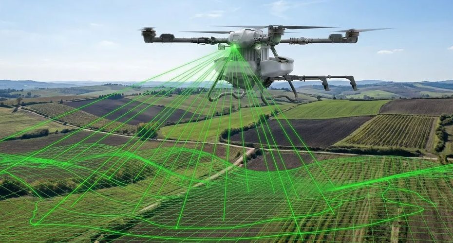
AI vision and RTK positioning replace static mission planning in spraying operations
Most current agricultural spraying drones still depend on a workflow that looks more like surveying than farming. Operators map the field, generate flight paths, and repeat the process whenever conditions change. In stable, uniform fields this is manageable. In oil palm, sugarcane, or mixed terrain, it becomes a bottleneck.
Geodash is removing that step.
The platform combines real-time machine vision with RTK GNSS positioning to handle navigation and spraying decisions during the flight itself. Instead of relying on predefined routes, the drone interprets field structure in real time. That includes row detection, canopy height variation, and terrain changes.
RTK accuracy in this context is not new. What matters is how it is used. The positioning layer provides centimeter-level stability for path control, while the vision system handles interpretation of what the drone is actually flying over. This reduces dependence on preloaded maps and allows the system to adapt immediately after replanting, erosion events, or irregular growth patterns.
Variable-rate spraying and terrain-following become real-time processes, not preloaded assumptions
From an operational standpoint, the shift is not just about navigation. It directly impacts application quality.
The system adjusts altitude and spray rate dynamically based on canopy structure and terrain. In theory, this allows consistent droplet placement even in uneven fields or multi-age plantations where plant height varies significantly.
This is particularly relevant in oil palm and sugarcane, where uniform coverage is difficult to maintain with fixed flight plans. Traditional drones either over-apply in low areas or under-apply in dense canopy zones. A perception-driven system can correct this in real time, assuming the sensing and control loop is fast and stable enough.
Geodash also claims tree-level or zone-level variable rate application. That suggests segmentation is happening onboard rather than in a pre-processed prescription map. The limitation here will depend on processing latency and sensor resolution, which have not been disclosed.
Continuous data capture turns spraying flights into agronomic intelligence streams
One of the more strategic elements is the backend.
Each flight feeds data into an AI-based analytics layer that generates outputs such as canopy density mapping, stress detection, and spray validation. This effectively turns every spraying mission into a scouting operation.
The concept is not new, but integration at the spraying stage is still limited in most commercial systems. Typically, scouting and spraying remain separate workflows. Combining them reduces operational passes and compresses decision cycles.
The value depends on data quality and consistency across flights. If the system can maintain stable georeferencing and repeatability, it could support trend analysis over time. If not, it risks becoming just another data layer with limited practical use.
Industrial agriculture focus highlights where automation pressure is highest
Geodash is not positioning this for small farms.
The target markets are clear:
- Oil palm plantations in Southeast Asia.
- Sugarcane, soybean, and corn operations in the United States.
- Large-scale estates across South America.
These are environments where labor constraints, scale, and terrain variability make automation economically relevant. Removing pre-mapping alone can significantly increase daily hectare coverage per team.
That said, the real test will be reliability. Large operators will prioritize uptime, serviceability, and regulatory compliance over feature sets. The system includes geofencing, logging, and audit capabilities, which are becoming mandatory in regulated spraying operations.
Hardware platform details remain limited but heavy-lift category is confirmed
The announced platform, referred to as the GDA80-120, is described as a heavy-lift agricultural UAV. However, specific technical parameters such as payload capacity, tank size, flight endurance, or swath width have not been disclosed.
Without those numbers, it is difficult to benchmark against existing platforms from DJI Agras or XAG, which dominate this segment. The differentiation here is clearly positioned around software architecture rather than raw hardware performance.
About DroneDash Technologies
Limited public data is available on scale or installed base. The company positions itself around AI vision systems and smart farming software. Its core contribution to the joint venture appears to be perception and analytics infrastructure.
About Geodnet
Geodnet operates a decentralized RTK correction network based on GNSS reference stations. The network has been expanding globally, with thousands of active nodes contributing correction data. Its role in the project is to provide centimeter-level positioning without relying on traditional single-provider RTK infrastructure.
About Geodash Aerosystems
Newly formed entity headquartered in Singapore. Focused on industrial agriculture UAV deployment. Commercial rollout is planned for Q3 2026 following regulatory clearance and manufacturing readiness.


