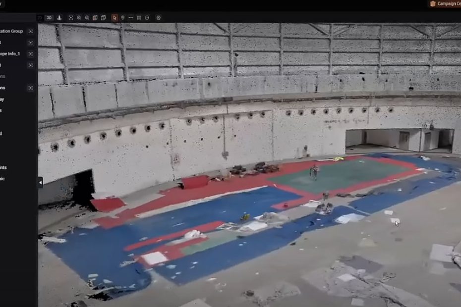
CHC Navigation (CHCNAV) has introduced a major update to its CoCloud platform, improving cloud-based LiDAR processing, 3D model visualization, and automated data preparation for surveying and reality capture projects. The upgrade is particularly relevant to users of the CHCNAV RS7 handheld SLAM scanner, which combines laser scanning, inertial navigation, and digital imaging to capture complex indoor environments.
According to the company, expanded server capacity allows CoCloud to complete processing tasks approximately 20% faster on average than a local workstation. A redesigned rendering engine also enables rapid visualization of large 3D Gaussian Splatting (3DGS) datasets, while new AI-assisted tools simplify point cloud cleaning and project management.
CoCloud Processing Gets 20% Faster
The processing improvements come from expanded dedicated cloud computing infrastructure, which CHCNAV says reduces queues and accelerates the generation of 3D deliverables.
Rather than requiring users to process every dataset on a high-performance desktop computer, CoCloud provides remote computing resources for operations such as point cloud generation, 3D mesh reconstruction, and Gaussian Splatting model production.
CHCNAV reports that average processing times are now approximately 20% shorter than those achieved on a local workstation. However, the company has not disclosed the benchmark workstation specifications, dataset sizes, or detailed testing conditions behind this comparison.
For surveying companies handling multiple projects, the advantage could extend beyond processing speed. Moving computationally intensive operations into the cloud allows local workstations to remain available for CAD, BIM, and other engineering tasks.
Faster 3D Gaussian Splatting Visualization
One of the most technically significant changes is CoCloud’s new 3D rendering engine, which improves the loading and navigation of point clouds, mesh models, and 3DGS deliverables.
CHCNAV states that a 5 GB Gaussian Splatting model can be preloaded across an entire scene within seconds. Instead of transferring every detail immediately, the platform loads full-resolution information on demand as users navigate toward individual objects or sections of the model.
This approach reduces unnecessary data transfer and makes large-scale visualization more practical over limited-bandwidth connections.
Unlike traditional polygon-based 3D rendering, Gaussian Splatting represents scenes using spatially distributed primitives that encode properties such as position, color, opacity, and shape. These elements can reproduce complex visual details, including surface textures and irregular geometry, without requiring a conventional polygon mesh for every visible feature.
For architectural documentation, industrial facility inspections, and heritage preservation, the technology provides a practical way to present realistic 3D environments to clients who may not have specialized point cloud software.
However, photorealistic 3DGS visualization should not be confused with independently verified survey accuracy. Precise dimensional measurements still depend on the underlying geometric data and appropriate quality control.
AI Point Cloud Filtering and Denoising
The latest CoCloud release also integrates selected advanced processing functions previously available through CHCNAV’s CoPre software.
Among the additions are AI-based pedestrian filtering and point cloud denoising.
Pedestrian filtering is particularly useful when scanning occupied buildings, transportation facilities, shopping centers, and other environments where people move through the measurement area. Removing unwanted moving objects can reduce visual artifacts and simplify subsequent modeling.
Point cloud denoising addresses isolated or unwanted measurements that may appear because of reflective surfaces, difficult scanning angles, environmental conditions, or sensor limitations.
These functions can reduce manual cleanup requirements, although automated filtering still needs inspection when preserving critical geometric details.
CHCNAV has additionally introduced estimated processing times and an updated progress interface, allowing operators to monitor individual jobs and better anticipate when deliverables will be available.
CHCNAV RS7 Scanner Specs
The CoCloud upgrade complements CHCNAV’s RS7 handheld LiDAR scanner, introduced in February 2026 for indoor surveying, building information modeling, renovation planning, and three-dimensional documentation.
The RS7 combines a 64-channel LiDAR sensor with an inertial navigation system and Simultaneous Localization and Mapping (SLAM) algorithms. This configuration allows the scanner to track its position while collecting spatial data in corridors, staircases, and other environments where GNSS reception may be unreliable or unavailable.
Its principal technical specifications include:
| Specification | CHCNAV RS7 |
|---|---|
| LiDAR measurement rate | Up to 1,152,000 points/sec |
| Laser channels | 64 |
| Scanning range | Up to 40 m at 10% reflectivity |
| Field of view | 360° × 189° |
| Relative accuracy | Better than 1 cm |
| Absolute accuracy | Better than 3 cm RMS under specified conditions |
| IMU update rate | 500 Hz |
| Gyroscope bias instability | 0.5°/hour |
| Camera system | Dual 48 MP sensors with 12 MP binned imaging |
| Internal storage | 512 GB |
| Battery operation | Up to 150 minutes |
| Weight | Approximately 1.2 kg |
| Protection rating | IP64 |
The scanner supports colorized point clouds, 3D mesh reconstruction, and Gaussian Splatting outputs through CHCNAV’s processing software ecosystem.
Its combination of high-rate LiDAR acquisition and inertial tracking makes it especially suitable for interior mapping, including spaces with repetitive geometry where conventional visual SLAM systems may struggle.
The technical specifications come from CHCNAV’s published RS7 documentation, with accuracy and battery performance subject to stated testing conditions.
Cloud-Based Reality Capture Workflow
CoCloud forms part of a broader CHCNAV software environment that connects field acquisition, data processing, and project delivery.
The RS7 can be operated using the SmartGo Neo mobile application, which supports device management, project organization, point cloud previews, and data uploads. CHCNAV’s CoPre software provides additional processing and modeling capabilities, while CoProcess supports more specialized point cloud operations and CAD-oriented workflows.
The updated CoCloud platform extends this environment by handling more processing tasks remotely and making completed results easier to inspect and share.
CHCNAV has also added a project case gallery containing more than a dozen selected examples from different industries. These include 3D models and completed project deliverables that users can reference when preparing technical proposals, presenting scanning capabilities, or demonstrating potential applications to customers.
Why This CoCloud Update Matters
The most important aspect of this release is not the reported 20% processing improvement by itself. It is CHCNAV’s effort to reduce the amount of specialized computing equipment and software expertise required after field scanning.
Handheld LiDAR systems can collect millions of measurements within seconds, but converting those measurements into useful engineering data remains a substantial part of the overall workflow. Processing delays, large file sizes, and manual data cleanup can reduce the productivity gains achieved during scanning.
By moving more processing functions into CoCloud, CHCNAV is addressing this less visible but commercially important stage of reality capture.
The improved 3DGS engine is particularly relevant because customer presentations increasingly require navigable, photorealistic models rather than static screenshots or conventional point cloud views.
Nevertheless, cloud processing introduces considerations that are less important in fully local workflows, including upload bandwidth, data security requirements, service availability, and long-term operating costs. Organizations working with confidential industrial facilities or sensitive infrastructure may also need to evaluate where project data is stored and processed.
CHCNAV has not provided enough public benchmark information to establish whether the reported processing advantage applies consistently across different dataset sizes and network conditions.
For professional surveying teams, the decisive measurement will be total project turnaround time, from completed field acquisition to verified, usable deliverables, rather than cloud processing speed alone.
About CHC Navigation
Founded in 2003 and headquartered in Shanghai, China, CHC Navigation develops GNSS positioning, LiDAR scanning, surveying, machine control, autonomous navigation, and precision agriculture technologies.
The company reports more than 2,200 employees and a distribution network spanning over 140 countries. CHCNAV has been listed on the Shenzhen Stock Exchange since 2017 under stock code 300627.SZ.
Its product portfolio includes professional GNSS receivers, mobile mapping systems, airborne and handheld LiDAR scanners, agricultural auto-steering equipment, and cloud-based geospatial software.