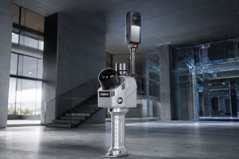
CHC Navigation is preparing to showcase a new reality capture workflow that combines its RS7 handheld SLAM laser scanner with the newly introduced Insta360 X6 360-degree camera, targeting the rapidly growing use of 3D Gaussian Splatting for photorealistic digital reconstruction.
The RS7 and Insta360 X6 integration will make its industry debut at INTERGEO 2026 in Munich, Germany, on September 15 through 17. CHCNAV says the concept combines SLAM-based spatial data captured by the RS7 with high-resolution panoramic imagery from the X6 to create more visually realistic and immersive 3DGS environments.
The approach is noteworthy because it brings together two data types that solve different parts of the reality capture problem. LiDAR provides spatial structure and geometry, while high-quality 360-degree imagery provides the visual information needed to reproduce surfaces, lighting and scene appearance.
RS7 SLAM Scanner Provides the Geometry
At the center of the system is the CHCNAV RS7, a handheld real-time 3D LiDAR scanner designed primarily for buildings, indoor mapping, architecture and other reality capture applications.
The RS7 uses a 64-channel LiDAR sensor with a maximum specified range of 40 meters. It can capture up to 576,000 points per second in single-return mode and as many as 1.152 million points per second in dual-return operation. CHCNAV also specifies an unusually wide 360 by 189-degree field of view, which is particularly valuable when scanning ceilings, structural elements and confined interiors while walking through a site.
Instead of requiring the operator to establish a large number of stationary tripod positions, the scanner uses SLAM technology to estimate its movement through the environment while continuously building the surrounding point cloud.
That makes the RS7 particularly relevant for indoor reality capture, where conventional GNSS positioning may be unavailable and where speed of data acquisition can be more important than achieving survey control at every individual scanner location.
Insta360 X6 Adds 8K Visual Capture
The imaging side of the workflow is provided by the Insta360 X6, the company’s latest flagship 360-degree camera.
The X6 records native 8K 360-degree video at up to 50 frames per second and uses two customized Sony sensors designed to provide what Insta360 describes as 1-inch equivalent 360 imaging. The camera also incorporates three processing chips, including a 4 nm Qualcomm processor and two dedicated imaging processors.
According to Insta360, the system provides a maximum dynamic range of 14.5 stops and captures substantially more light per pixel than the previous generation. The X6 also includes PureVideo processing aimed at improving detail and suppressing noise in darker scenes.
Those capabilities matter considerably more in a 3D reconstruction workflow than the headline 8K resolution alone.
For Gaussian Splatting, inconsistent exposure, motion blur, excessive image noise and lost detail in shadows can all affect the visual information available during reconstruction. Indoor environments are particularly challenging because a single scan can include windows, artificial lighting, dark rooms and reflective surfaces within the same sequence.
The larger imaging system, HDR capabilities and low-light processing of the X6 therefore address a practical weakness of many compact imaging systems used alongside portable scanners.
3D Gaussian Splatting Changes the Output
The most interesting aspect of the collaboration is not simply attaching a 360-degree camera to a scanner. Similar combinations of LiDAR and imagery have existed for years.
The difference is the intended output.
3D Gaussian Splatting, commonly abbreviated as 3DGS, is a scene representation and rendering technique that has gained significant attention since the original method was published in 2023. Instead of relying only on traditional polygon meshes and textures, the method represents a scene using large numbers of optimized three-dimensional Gaussian primitives.
The original research demonstrated high-quality novel-view synthesis while supporting real-time rendering at 1080p under its test conditions.
That characteristic makes 3DGS attractive for applications where the objective is not simply to measure a building or produce a point cloud, but to create an environment that can be explored visually from different viewpoints.
This potentially expands reality capture into digital twins, architectural visualization, cultural heritage documentation, property documentation, industrial facilities, immersive training and interactive presentations.
LiDAR and Imagery Solve Different Problems
This is where the RS7 plus X6 concept becomes technically interesting.
A dense LiDAR point cloud can describe the physical structure of an environment extremely well, but a colored point cloud still does not necessarily look like the real environment when viewed interactively.
A conventional 360-degree camera solves the opposite problem. It can record rich visual information, but images by themselves do not provide the same direct geometric measurement capabilities as LiDAR.
Pairing the two creates a complementary capture system.
The RS7 can provide the spatial framework and continuous trajectory information, while the X6 collects high-resolution imagery from virtually every viewing direction. The resulting datasets can then serve workflows intended to combine measurable spatial information with photorealistic visualization.
CHCNAV has not yet published detailed specifications for the complete RS7 plus X6 processing pipeline, such as synchronization methodology, calibration procedure, processing time or the precise software chain used to produce the final Gaussian Splatting model. Those details will be important in evaluating how streamlined the workflow is in professional field use.
Why the Workflow Matters
The biggest opportunity here may be workflow efficiency rather than image quality alone.
Reality capture has historically involved several separate stages. A surveyor captures geometry, cameras collect imagery, data is registered, point clouds are cleaned, meshes may be generated, textures are created and the final model is prepared for visualization.
3DGS offers the potential to remove or simplify some of those traditional visualization steps.
For users who primarily need an immersive representation rather than a perfectly optimized CAD surface, that could substantially shorten the route from walking through a building to viewing a convincing digital version of it.
The RS7 is especially well suited to this concept because CHCNAV already positions the scanner for rapid indoor and building capture, BIM-related workflows and asset documentation.
Adding a high-quality omnidirectional imaging system effectively pushes the platform beyond conventional point-cloud acquisition toward visual reality capture.
A Practical Direction for Professional 3DGS
From a technical perspective, the significance of the RS7 and X6 combination is that it moves Gaussian Splatting closer to a repeatable field workflow rather than treating it solely as a computer graphics technique.
There are already many impressive 3DGS demonstrations created from cameras and video sequences. Professional geospatial users, however, need more than attractive rendering. They need predictable capture procedures, reliable trajectories, sufficient coverage and datasets that can be connected with existing surveying and spatial workflows.
LiDAR gives CHCNAV an important advantage here.
Rather than asking photogrammetry or computer vision algorithms to infer every part of the scene geometry from images, the workflow begins with a scanner specifically designed to measure the surrounding environment.
The Insta360 X6 then supplies the visual density needed to make that measured environment look convincing.
That combination is arguably more important than either product specification individually.
If CHCNAV can make synchronization, calibration and processing largely automatic, the system could represent a practical bridge between professional laser scanning and the rapidly evolving world of neural and Gaussian-based visualization.
INTERGEO 2026 Debut
CHCNAV plans to demonstrate the RS7 plus Insta360 X6 workflow at INTERGEO 2026, which takes place at Messe München in Munich from September 15 through 17.
The company will exhibit in Hall C6 at Stand D149.
INTERGEO describes its Munich event as a meeting point for the international geospatial and geo-IT community. Organizers expect more than 18,500 trade visitors, with participants representing 119 countries, making it a logical venue for CHCNAV to demonstrate a technology positioned at the intersection of surveying, reality capture and advanced visualization.
About CHC Navigation
Founded in Shanghai in 2003, CHC Navigation develops positioning, navigation and mapping technologies for geospatial surveying, construction, precision agriculture, machine control, autonomous systems and other applications.
The company currently reports more than 2,200 employees worldwide and a distributor network covering more than 140 countries. CHCNAV also states that its global workforce includes more than 1,000 research and development engineers. The company has been publicly listed on the Shenzhen Stock Exchange since 2017 under ticker 300627.SZ.
Its product portfolio now extends well beyond conventional GNSS receivers and includes terrestrial and mobile LiDAR systems, UAV mapping equipment, marine survey platforms, GNSS infrastructure, machine control technology, agricultural autosteering and autonomous navigation products.
The RS7 plus Insta360 X6 project is therefore a logical extension of CHCNAV’s broader move toward integrated reality capture systems rather than standalone positioning hardware.
Source:www.chcnav.com